Hunkuyi elevation
Hunkuyi (Kaduna, Kudan), Nigeria elevation is 653 meters and Hunkuyi elevation in feet is 2142 ft above sea level [src 1]. Hunkuyi is a seat of a second-order administrative division (feature code) with elevation that is 356 meters (1168 ft) bigger than average city elevation in Nigeria.
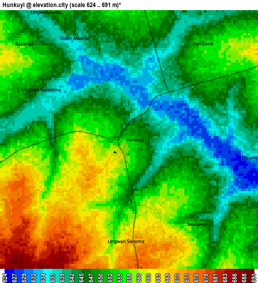
Below is the Elevation map of Hunkuyi, which displays elevation range with different colors. Scale of the first map is from 624 to 691 m (2047 to 2267 ft) with average elevation of 652.1 meters (=2139 ft) [note 1]
These maps also provides idea of topography and contour of this city, they are displayed at different zoom levels. More info about maps, scale and edge coordinates you can find below images.
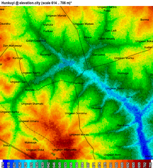
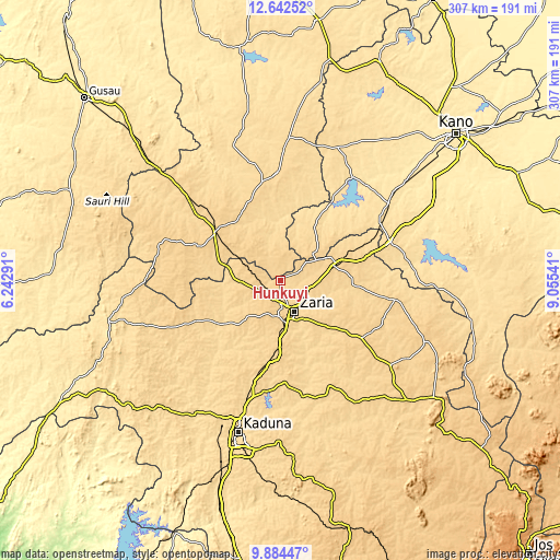
| \ | Map #1 | Map #2 | Topo.Map |
| Scale [m] | 624..691 m | 614..706 m | × |
| Scale [ft] | 2047..2267 ft | 2014..2316 ft | × |
| Average | 652.1 m = 2139 ft | 660.1 m = 2166 ft | × |
| Width | 9.58 km = 6 mi | 19.17 km = 11.9 mi | 306.7 km = 190.6 mi |
| Height | 9.58 km = 6 mi | 19.17 km = 11.9 mi | 306.7 km = 190.6 mi |
| ↑Max Latitude | 11.309895° | 11.352984° | 12.64252° |
| Latitude at center | 11.2668° | 11.2668° | 11.2668° |
| ↓Min Latitude | 11.223698° | 11.18059° | 9.88447° |
| ← Min Longitude | 7.605215° | 7.561269° | 6.24291° |
| Longitude center | 7.64916° | 7.64916° | 7.64916° |
| →Max Longitude | 7.693105° | 7.737051° | 9.05541° |
Nearby cities:
Cities around Hunkuyi sort by population:
• Zaria elevation 644 m
19.1 km,  155°
155°
• Funtua 709 m
46.6 km,  307°
307°
• Malumfashi 618 m
58.2 km,  356°
356°
• Soba 683 m
54.7 km,  125°
125°
• Bakori 656 m
40.4 km,  322°
322°
• Danja 681 m
15.6 km, 321°
• Igabi 673 m
51.7 km,  172°
172°
• Kafur 587 m
42.4 km,  6°
6°
• Maigana 658 m
41.3 km, 130°
• Rogo 611 m
36.9 km,  30°
30°
• Makarfi 672 m
28.1 km,  64°
64°
• Giwa 680 m
22.4 km,  284°
284°
Multilingual:
 En español:
Hunkuyi elevación 653 m.
 En France:
Hunkuyi élévation 653 m.


Sources and notes:
- [note 1] Map square and city borders are not equal. Map elevation data is calculated only from area inside that square.
- [src 1] Elevation data from geonames database provided with same terms of usage.
- [src 2] The elevation map of Hunkuyi is generated using elevation data from NASA's 3 arcsec (90m) resolution SRTM data.
- [src 3] Base (background) map © OpenStreetMap contributors tiles are generated by Geofabrik and OpenTopoMap.
Copyright & License:
This Hunkuyi Elevation Map is licensed under CC BY-SA. You may reuse any part from this page, if you give a proper credit by linking to this URL:
 More info on terms of use page.