Igboho elevation
Igboho (Oyo, Orelope), Nigeria elevation is 405 meters and Igboho elevation in feet is 1329 ft above sea level [src 1]. Igboho is a seat of a second-order administrative division (feature code) with elevation that is 108 meters (354 ft) bigger than average city elevation in Nigeria.
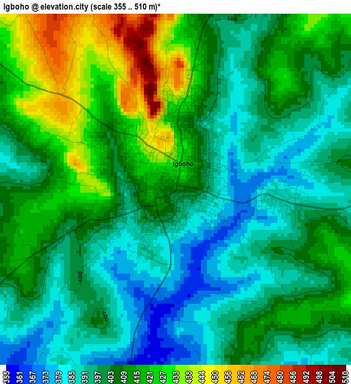
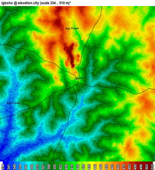
Below is the Elevation map of Igboho, which displays elevation range with different colors. Scale of the first map is from 355 to 510 m (1165 to 1673 ft) with average elevation of 405.4 meters (=1330 ft) [note 1]
These maps also provides idea of topography and contour of this city, they are displayed at different zoom levels. More info about maps, scale and edge coordinates you can find below images.
| \ | Map #1 | Map #2 | Topo.Map |
| Scale [m] | 355..510 m | 334..510 m | × |
| Scale [ft] | 1165..1673 ft | 1096..1673 ft | × |
| Average | 405.4 m = 1330 ft | 408.1 m = 1339 ft | × |
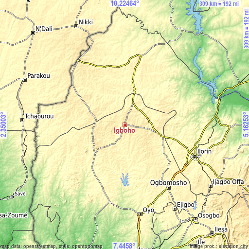
| Width | 9.66 km = 6 mi | 19.31 km = 12 mi | 309 km = 192 mi |
| Height | 9.66 km = 6 mi | 19.31 km = 12 mi | 309 km = 192 mi |
| ↑Max Latitude | 8.881261° | 8.924677° | 10.22464° |
| Latitude at center | 8.83784° | 8.83784° | 8.83784° |
| ↓Min Latitude | 8.794414° | 8.750983° | 7.4458° |
| ← Min Longitude | 3.712335° | 3.668389° | 2.35003° |
| Longitude center | 3.75628° | 3.75628° | 3.75628° |
| →Max Longitude | 3.800225° | 3.844171° | 5.16253° |
Nearby cities:
Cities around Igboho sort by population:
• Saki elevation 472 m
44.1 km,  244°
244°
• Kisi 371 m
29.2 km,  21°
21°
• Okuta 405 m
75.7 km,  303°
303°
• Igbeti 371 m
42.4 km,  103°
103°
• Kaiama 325 m
87.7 km,  13°
13°
• Ago Are 317 m
53 km,  224°
224°
• Alapa 357 m
73.2 km,  109°
109°
• Gwasero 355 m
77.1 km,  338°
338°
• Ikoyi-Ile 380 m
80.3 km,  145°
145°
• Otu 280 m
80 km,  208°
208°
• Tede 397 m
46.3 km,  227°
227°
• Ago-Amodu 356 m
28.5 km, 213°
Multilingual:
 En español:
Igboho elevación 405 m.
 En France:
Igboho élévation 405 m.


Sources and notes:
- [note 1] Map square and city borders are not equal. Map elevation data is calculated only from area inside that square.
- [src 1] Elevation data from geonames database provided with same terms of usage.
- [src 2] The elevation map of Igboho is generated using elevation data from NASA's 3 arcsec (90m) resolution SRTM data.
- [src 3] Base (background) map © OpenStreetMap contributors tiles are generated by Geofabrik and OpenTopoMap.
Copyright & License:
This Igboho Elevation Map is licensed under CC BY-SA. You may reuse any part from this page, if you give a proper credit by linking to this URL:
 More info on terms of use page.