Igbor elevation
Igbor (Benue, Gwer East), Nigeria elevation is 212 meters and Igbor elevation in feet is 696 ft above sea level [src 1]. Igbor is a populated place (feature code) with elevation that is 85 meters (279 ft) smaller than average city elevation in Nigeria.
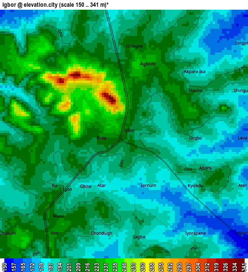
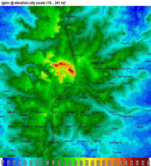
Below is the Elevation map of Igbor, which displays elevation range with different colors. Scale of the first map is from 150 to 341 m (492 to 1119 ft) with average elevation of 201.8 meters (=662 ft) [note 1]
These maps also provides idea of topography and contour of this city, they are displayed at different zoom levels. More info about maps, scale and edge coordinates you can find below images.
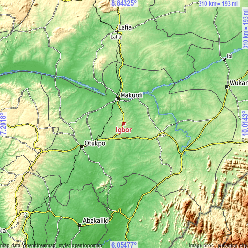
| \ | Map #1 | Map #2 | Topo.Map |
| Scale [m] | 150..341 m | 116..341 m | × |
| Scale [ft] | 492..1119 ft | 381..1119 ft | × |
| Average | 201.8 m = 662 ft | 177.7 m = 583 ft | × |
| Width | 9.69 km = 6 mi | 19.38 km = 12 mi | 310 km = 192.6 mi |
| Height | 9.69 km = 6 mi | 19.38 km = 12 mi | 310.1 km = 192.7 mi |
| ↑Max Latitude | 7.494802° | 7.53837° | 8.84325° |
| Latitude at center | 7.45123° | 7.45123° | 7.45123° |
| ↓Min Latitude | 7.407654° | 7.364073° | 6.05477° |
| ← Min Longitude | 8.564105° | 8.520159° | 7.2018° |
| Longitude center | 8.60805° | 8.60805° | 8.60805° |
| →Max Longitude | 8.651995° | 8.695941° | 10.0143° |
Nearby cities:
Cities around Igbor sort by population:
• Makurdi elevation 92 m
32.8 km,  343°
343°
• Aliade 161 m
22.1 km,  218°
218°
• Yandev 225 m
48.9 km,  101°
101°
• Oju 158 m
70.5 km,  197°
197°
• Buruku 93 m
65.8 km,  89°
89°
• Lessel 194 m
58 km,  128°
128°
• Obarike-Ito 82 m
56.9 km,  213°
213°
• Gbajimba 112 m
49.5 km,  34°
34°
• Naka 159 m
46.9 km,  288°
288°
• Gboko 226 m
45.6 km,  108°
108°
• Tse-Agberagba 110 m
42.1 km,  171°
171°
• Wannune 191 m
33 km,  67°
67°
Multilingual:
 En español:
Igbor elevación 212 m.
 En France:
Igbor élévation 212 m.


Sources and notes:
- [note 1] Map square and city borders are not equal. Map elevation data is calculated only from area inside that square.
- [src 1] Elevation data from geonames database provided with same terms of usage.
- [src 2] The elevation map of Igbor is generated using elevation data from NASA's 3 arcsec (90m) resolution SRTM data.
- [src 3] Base (background) map © OpenStreetMap contributors tiles are generated by Geofabrik and OpenTopoMap.
Copyright & License:
This Igbor Elevation Map is licensed under CC BY-SA. You may reuse any part from this page, if you give a proper credit by linking to this URL:
 More info on terms of use page.