Oju elevation
Oju (Benue), Nigeria elevation is 158 meters and Oju elevation in feet is 518 ft above sea level [src 1]. Oju is a seat of a second-order administrative division (feature code) with elevation that is 139 meters (456 ft) smaller than average city elevation in Nigeria.
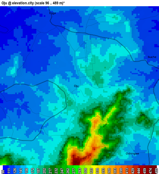
Below is the Elevation map of Oju, which displays elevation range with different colors. Scale of the first map is from 96 to 489 m (315 to 1604 ft) with average elevation of 160.4 meters (=526 ft) [note 1]
These maps also provides idea of topography and contour of this city, they are displayed at different zoom levels. More info about maps, scale and edge coordinates you can find below images.
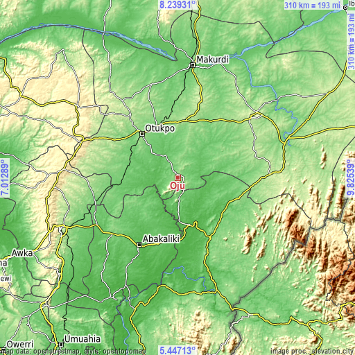
| \ | Map #1 | Topo.Map |
| Scale [m] | 96..489 m | × |
| Scale [ft] | 315..1604 ft | × |
| Average | 160.4 m = 526 ft | × |
| Width | 9.7 km = 6 mi | 310.5 km = 192.9 mi |
| Height | 9.7 km = 6 mi | 310.5 km = 192.9 mi |
| ↑Max Latitude | 6.88889° | 8.23931° |
| Latitude at center | 6.84526° | 6.84526° |
| ↓Min Latitude | 6.801626° | 5.44713° |
| ← Min Longitude | 8.375195° | 7.01289° |
| Longitude center | 8.41914° | 8.41914° |
| →Max Longitude | 8.463085° | 9.82539° |
Nearby cities:
Cities around Oju sort by population:
• Effium elevation 115 m
46.4 km,  239°
239°
• Ezza-Ohu 80 m
58.2 km,  219°
219°
• Ogoja 96 m
46.8 km,  116°
116°
• Aliade 161 m
50.6 km,  7°
7°
• Ochobo 127 m
60.9 km,  307°
307°
• Abuochiche 139 m
60.4 km,  106°
106°
• Iboko 78 m
52.9 km,  202°
202°
• Igumale 81 m
50.1 km,  263°
263°
• Ugbodo 89 m
49 km, 220°
• Tse-Agberagba 110 m
37.4 km,  46°
46°
• Okpoma 77 m
36.7 km,  138°
138°
• Obarike-Ito 82 m
22.5 km,  332°
332°
Multilingual:
 En español:
Oju elevación 158 m.
 En France:
Oju élévation 158 m.


Sources and notes:
- [note 1] Map square and city borders are not equal. Map elevation data is calculated only from area inside that square.
- [src 1] Elevation data from geonames database provided with same terms of usage.
- [src 2] The elevation map of Oju is generated using elevation data from NASA's 3 arcsec (90m) resolution SRTM data.
- [src 3] Base (background) map © OpenStreetMap contributors tiles are generated by Geofabrik and OpenTopoMap.
Copyright & License:
This Oju Elevation Map is licensed under CC BY-SA. You may reuse any part from this page, if you give a proper credit by linking to this URL:
 More info on terms of use page.