Yandev elevation
Yandev (Benue, Gboko), Nigeria elevation is 225 meters and Yandev elevation in feet is 738 ft above sea level [src 1]. Yandev is a populated place (feature code) with elevation that is 72 meters (236 ft) smaller than average city elevation in Nigeria.
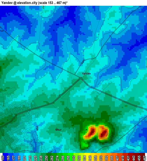
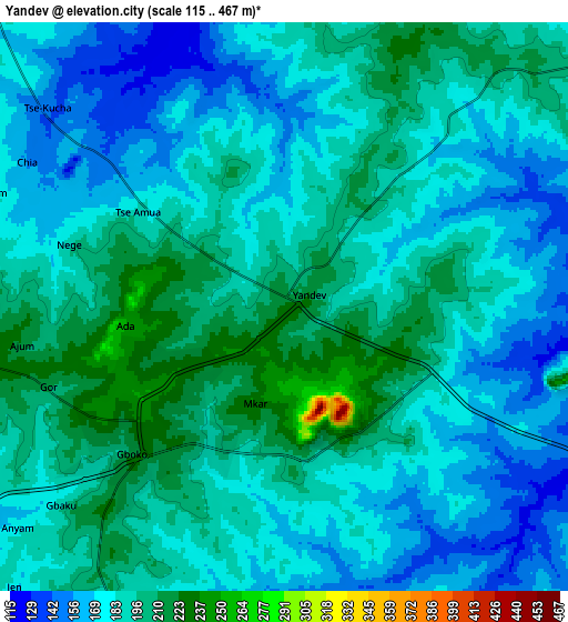
Below is the Elevation map of Yandev, which displays elevation range with different colors. Scale of the first map is from 153 to 467 m (502 to 1532 ft) with average elevation of 210 meters (=689 ft) [note 1]
These maps also provides idea of topography and contour of this city, they are displayed at different zoom levels. More info about maps, scale and edge coordinates you can find below images.
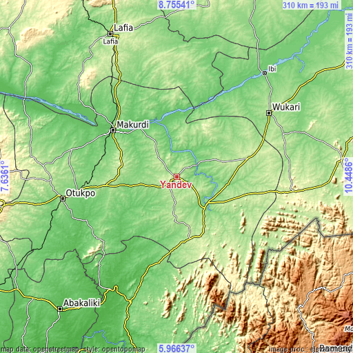
| \ | Map #1 | Map #2 | Topo.Map |
| Scale [m] | 153..467 m | 115..467 m | × |
| Scale [ft] | 502..1532 ft | 377..1532 ft | × |
| Average | 210 m = 689 ft | 185.2 m = 608 ft | × |
| Width | 9.69 km = 6 mi | 19.38 km = 12 mi | 310.1 km = 192.7 mi |
| Height | 9.69 km = 6 mi | 19.38 km = 12 mi | 310.1 km = 192.7 mi |
| ↑Max Latitude | 7.406661° | 7.450237° | 8.75541° |
| Latitude at center | 7.36308° | 7.36308° | 7.36308° |
| ↓Min Latitude | 7.319495° | 7.275906° | 5.96637° |
| ← Min Longitude | 8.998405° | 8.954459° | 7.6361° |
| Longitude center | 9.04235° | 9.04235° | 9.04235° |
| →Max Longitude | 9.086295° | 9.130241° | 10.4486° |
Nearby cities:
Cities around Yandev sort by population:
• Katsina-Ala elevation 152 m
34.3 km,  128°
128°
• Igbor 212 m
48.9 km,  281°
281°
• Aliade 161 m
62.2 km,  263°
263°
• Vandeikya 157 m
64.4 km,  177°
177°
• Adikpo 241 m
56.7 km,  158°
158°
• Gbajimba 112 m
54.7 km,  338°
338°
• Tse-Agberagba 110 m
52.4 km,  232°
232°
• Ugba 189 m
37.3 km,  64°
64°
• Wannune 191 m
28.2 km,  322°
322°
• Lessel 194 m
26.3 km,  185°
185°
• Buruku 93 m
20.9 km, 59°
• Gboko 226 m
6.4 km, 225°
Multilingual:
 En español:
Yandev elevación 225 m.
 En France:
Yandev élévation 225 m.


Sources and notes:
- [note 1] Map square and city borders are not equal. Map elevation data is calculated only from area inside that square.
- [src 1] Elevation data from geonames database provided with same terms of usage.
- [src 2] The elevation map of Yandev is generated using elevation data from NASA's 3 arcsec (90m) resolution SRTM data.
- [src 3] Base (background) map © OpenStreetMap contributors tiles are generated by Geofabrik and OpenTopoMap.
Copyright & License:
This Yandev Elevation Map is licensed under CC BY-SA. You may reuse any part from this page, if you give a proper credit by linking to this URL:
 More info on terms of use page.