Katsina-Ala elevation
Katsina-Ala (Benue), Nigeria elevation is 152 meters and Katsina-Ala elevation in feet is 499 ft above sea level [src 1]. Katsina-Ala is a seat of a second-order administrative division (feature code) with elevation that is 145 meters (476 ft) smaller than average city elevation in Nigeria.
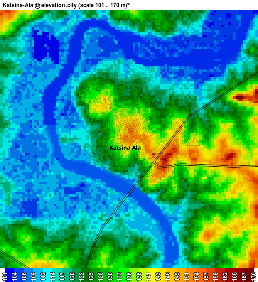
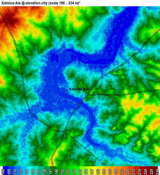
Below is the Elevation map of Katsina-Ala, which displays elevation range with different colors. Scale of the first map is from 101 to 170 m (331 to 558 ft) with average elevation of 120.7 meters (=396 ft) [note 1]
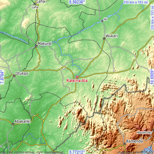
These maps also provides idea of topography and contour of this city, they are displayed at different zoom levels. More info about maps, scale and edge coordinates you can find below images.
| \ | Map #1 | Map #2 | Topo.Map |
| Scale [m] | 101..170 m | 100..234 m | × |
| Scale [ft] | 331..558 ft | 328..768 ft | × |
| Average | 120.7 m = 396 ft | 139.2 m = 457 ft | × |
| Width | 9.7 km = 6 mi | 19.39 km = 12 mi | 310.2 km = 192.7 mi |
| Height | 9.7 km = 6 mi | 19.39 km = 12 mi | 310.3 km = 192.8 mi |
| ↑Max Latitude | 7.21298° | 7.256575° | 8.56236° |
| Latitude at center | 7.16938° | 7.16938° | 7.16938° |
| ↓Min Latitude | 7.125776° | 7.082168° | 5.77212° |
| ← Min Longitude | 9.240705° | 9.196759° | 7.8784° |
| Longitude center | 9.28465° | 9.28465° | 9.28465° |
| →Max Longitude | 9.328595° | 9.372541° | 10.6909° |
Nearby cities:
Cities around Katsina-Ala sort by population:
• Obudu elevation 224 m
57.3 km,  193°
193°
• Zaki Biam 204 m
51.9 km,  43°
43°
• Yandev 225 m
34.3 km,  308°
308°
• Gakem 162 m
55 km,  216°
216°
• Wannune 191 m
62.1 km, 314°
• Sankera 208 m
57.4 km, 44°
• Vandeikya 157 m
49 km,  209°
209°
• Ugba 189 m
38.2 km,  10°
10°
• Gboko 226 m
35.6 km,  298°
298°
• Buruku 93 m
33.5 km,  344°
344°
• Adikpo 241 m
31.6 km, 190°
• Lessel 194 m
29.6 km,  260°
260°
Multilingual:
 En español:
Katsina-Ala elevación 152 m.
 En France:
Katsina-Ala élévation 152 m.
 Auf Deutsch:
Katsina-Ala höhe über dem Meeresspiegel ist 152 m.

Sources and notes:
- [note 1] Map square and city borders are not equal. Map elevation data is calculated only from area inside that square.
- [src 1] Elevation data from geonames database provided with same terms of usage.
- [src 2] The elevation map of Katsina-Ala is generated using elevation data from NASA's 3 arcsec (90m) resolution SRTM data.
- [src 3] Base (background) map © OpenStreetMap contributors tiles are generated by Geofabrik and OpenTopoMap.
Copyright & License:
This Katsina-Ala Elevation Map is licensed under CC BY-SA. You may reuse any part from this page, if you give a proper credit by linking to this URL:
 More info on terms of use page.