Nasarawa elevation
Nasarawa (Nassarawa), Nigeria elevation is 185 meters and Nasarawa elevation in feet is 607 ft above sea level [src 1]. Nasarawa is a seat of a second-order administrative division (feature code) with elevation that is 112 meters (367 ft) smaller than average city elevation in Nigeria.
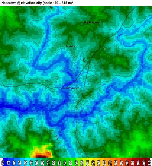
Below is the Elevation map of Nasarawa, which displays elevation range with different colors. Scale of the first map is from 170 to 315 m (558 to 1033 ft) with average elevation of 203.9 meters (=669 ft) [note 1]
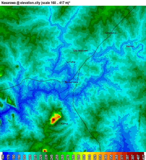
These maps also provides idea of topography and contour of this city, they are displayed at different zoom levels. More info about maps, scale and edge coordinates you can find below images.
| \ | Map #1 | Map #2 | Topo.Map |
| Scale [m] | 170..315 m | 160..417 m | × |
| Scale [ft] | 558..1033 ft | 525..1368 ft | × |
| Average | 203.9 m = 669 ft | 215 m = 705 ft | × |
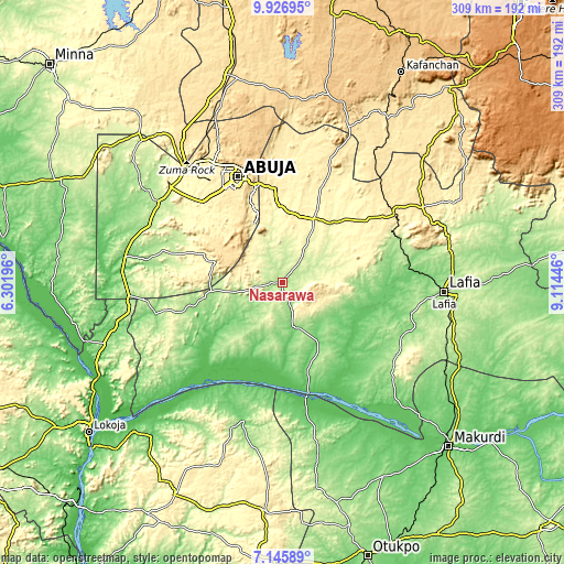
| Width | 9.66 km = 6 mi | 19.33 km = 12 mi | 309.2 km = 192.1 mi |
| Height | 9.66 km = 6 mi | 19.33 km = 12 mi | 309.3 km = 192.2 mi |
| ↑Max Latitude | 8.582406° | 8.625856° | 9.92695° |
| Latitude at center | 8.53895° | 8.53895° | 8.53895° |
| ↓Min Latitude | 8.495489° | 8.452024° | 7.14589° |
| ← Min Longitude | 7.664265° | 7.620319° | 6.30196° |
| Longitude center | 7.70821° | 7.70821° | 7.70821° |
| →Max Longitude | 7.752155° | 7.796101° | 9.11446° |
Nearby cities:
Cities around Nasarawa sort by population:
• Abuja elevation 476 m
62.3 km,  337°
337°
• Kuje 300 m
65 km,  305°
305°
• Keffi 321 m
38.7 km,  27°
27°
• Doma 157 m
73 km,  102°
102°
• Buga 187 m
40.7 km,  262°
262°
• Bugana 89 m
61.6 km,  192°
192°
• Gwagwalada 186 m
82.2 km,  303°
303°
• Abejukolo 109 m
77.7 km,  196°
196°
• Obagaji 72 m
75.3 km,  162°
162°
• Toto 140 m
71.4 km, 256°
• Garaku 378 m
57.7 km,  53°
53°
• Karu 390 m
52.6 km,  354°
354°
Multilingual:
 En español:
Nasarawa elevación 185 m.
 En France:
Nasarawa élévation 185 m.
 Auf Deutsch:
Nasarawa höhe über dem Meeresspiegel ist 185 m.

Sources and notes:
- [note 1] Map square and city borders are not equal. Map elevation data is calculated only from area inside that square.
- [src 1] Elevation data from geonames database provided with same terms of usage.
- [src 2] The elevation map of Nasarawa is generated using elevation data from NASA's 3 arcsec (90m) resolution SRTM data.
- [src 3] Base (background) map © OpenStreetMap contributors tiles are generated by Geofabrik and OpenTopoMap.
Copyright & License:
This Nasarawa Elevation Map is licensed under CC BY-SA. You may reuse any part from this page, if you give a proper credit by linking to this URL:
 More info on terms of use page.