Takum elevation
Takum (Benue), Nigeria elevation is 256 meters and Takum elevation in feet is 840 ft above sea level [src 1]. Takum is a populated place (feature code) with elevation that is 41 meters (135 ft) smaller than average city elevation in Nigeria.
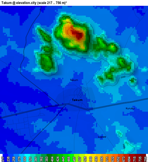
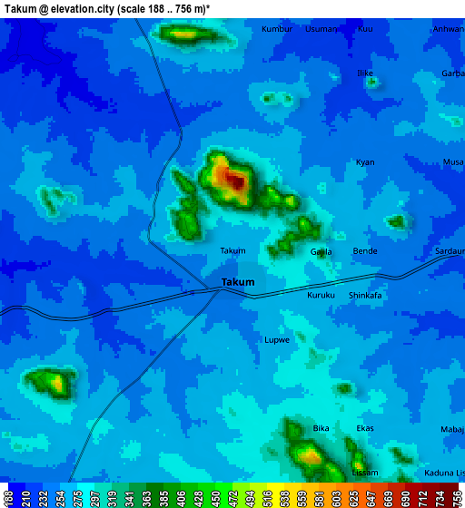
Below is the Elevation map of Takum, which displays elevation range with different colors. Scale of the first map is from 217 to 756 m (712 to 2480 ft) with average elevation of 279 meters (=915 ft) [note 1]
These maps also provides idea of topography and contour of this city, they are displayed at different zoom levels. More info about maps, scale and edge coordinates you can find below images.
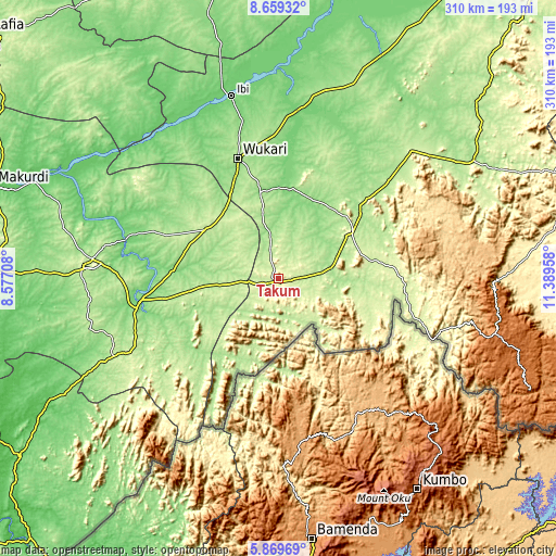
| \ | Map #1 | Map #2 | Topo.Map |
| Scale [m] | 217..756 m | 188..756 m | × |
| Scale [ft] | 712..2480 ft | 617..2480 ft | × |
| Average | 279 m = 915 ft | 260.1 m = 853 ft | × |
| Width | 9.69 km = 6 mi | 19.39 km = 12 mi | 310.2 km = 192.7 mi |
| Height | 9.69 km = 6 mi | 19.39 km = 12 mi | 310.2 km = 192.7 mi |
| ↑Max Latitude | 7.31026° | 7.353846° | 8.65932° |
| Latitude at center | 7.26667° | 7.26667° | 7.26667° |
| ↓Min Latitude | 7.223076° | 7.179477° | 5.86969° |
| ← Min Longitude | 9.939385° | 9.895439° | 8.57708° |
| Longitude center | 9.98333° | 9.98333° | 9.98333° |
| →Max Longitude | 10.027275° | 10.071221° | 11.38958° |
Nearby cities:
Cities around Takum sort by population:
• Wukari elevation 189 m
71 km,  341°
341°
• Katsina-Ala 152 m
77.8 km,  262°
262°
• Zaki Biam 204 m
49 km,  302°
302°
• Baissa 248 m
70.8 km,  93°
93°
• Yandev 225 m
104.3 km,  275°
275°
• Riti 127 m
82 km,  330°
330°
• Adikpo 241 m
92.7 km,  243°
243°
• Buruku 93 m
88.5 km, 284°
• Ugba 189 m
75 km,  290°
290°
• Donga 136 m
51.1 km,  7°
7°
• Sankera 208 m
47.2 km,  309°
309°
• Lissam 271 m
10.5 km,  138°
138°
Multilingual:
 En español:
Takum elevación 256 m.
 En France:
Takum élévation 256 m.


Sources and notes:
- [note 1] Map square and city borders are not equal. Map elevation data is calculated only from area inside that square.
- [src 1] Elevation data from geonames database provided with same terms of usage.
- [src 2] The elevation map of Takum is generated using elevation data from NASA's 3 arcsec (90m) resolution SRTM data.
- [src 3] Base (background) map © OpenStreetMap contributors tiles are generated by Geofabrik and OpenTopoMap.
Copyright & License:
This Takum Elevation Map is licensed under CC BY-SA. You may reuse any part from this page, if you give a proper credit by linking to this URL:
 More info on terms of use page.