Umulona elevation
Umulona (Enugu, Uzo-Uwani), Nigeria elevation is 71 meters and Umulona elevation in feet is 233 ft above sea level [src 1]. Umulona is a seat of a second-order administrative division (feature code) with elevation that is 226 meters (741 ft) smaller than average city elevation in Nigeria.
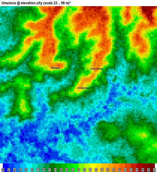
Below is the Elevation map of Umulona, which displays elevation range with different colors. Scale of the first map is from 23 to 98 m (75 to 322 ft) with average elevation of 49.8 meters (=163 ft) [note 1]
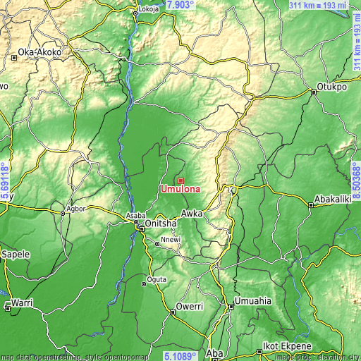
These maps also provides idea of topography and contour of this city, they are displayed at different zoom levels. More info about maps, scale and edge coordinates you can find below images.
| \ | Map #1 | Topo.Map |
| Scale [m] | 23..98 m | × |
| Scale [ft] | 75..322 ft | × |
| Average | 49.8 m = 163 ft | × |
| Width | 9.71 km = 6 mi | 310.7 km = 193.1 mi |
| Height | 9.71 km = 6 mi | 310.7 km = 193.1 mi |
| ↑Max Latitude | 6.55155° | 7.903° |
| Latitude at center | 6.50789° | 6.50789° |
| ↓Min Latitude | 6.464226° | 5.1089° |
| ← Min Longitude | 7.053485° | 5.69118° |
| Longitude center | 7.09743° | 7.09743° |
| →Max Longitude | 7.141375° | 8.50368° |
Nearby cities:
Cities around Umulona sort by population:
• Awka elevation 99 m
32.9 km,  184°
184°
• Aku 299 m
33.1 km,  47°
47°
• Ogurugu 54 m
35 km,  332°
332°
• Adani 59 m
27.5 km,  339°
339°
• Ukpo 198 m
35.7 km,  203°
203°
• Ogbede 361 m
35.7 km,  59°
59°
• Oji River 74 m
33.9 km,  145°
145°
• Otuocha 55 m
33.5 km,  235°
235°
• Nteje 125 m
33.1 km,  216°
216°
• Aguobu-Owa 200 m
24.5 km,  128°
128°
• Achalla 84 m
22.7 km,  211°
211°
• Anaku 68 m
19.1 km,  256°
256°
Multilingual:
 En español:
Umulona elevación 71 m.
 En France:
Umulona élévation 71 m.


Sources and notes:
- [note 1] Map square and city borders are not equal. Map elevation data is calculated only from area inside that square.
- [src 1] Elevation data from geonames database provided with same terms of usage.
- [src 2] The elevation map of Umulona is generated using elevation data from NASA's 3 arcsec (90m) resolution SRTM data.
- [src 3] Base (background) map © OpenStreetMap contributors tiles are generated by Geofabrik and OpenTopoMap.
Copyright & License:
This Umulona Elevation Map is licensed under CC BY-SA. You may reuse any part from this page, if you give a proper credit by linking to this URL:
 More info on terms of use page.