Wagini elevation
Wagini (Katsina, Batsari), Nigeria elevation is 488 meters and Wagini elevation in feet is 1601 ft above sea level [src 1]. Wagini is a populated place (feature code) with elevation that is 191 meters (627 ft) bigger than average city elevation in Nigeria.
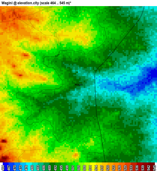
Below is the Elevation map of Wagini, which displays elevation range with different colors. Scale of the first map is from 464 to 545 m (1522 to 1788 ft) with average elevation of 497.9 meters (=1634 ft) [note 1]
These maps also provides idea of topography and contour of this city, they are displayed at different zoom levels. More info about maps, scale and edge coordinates you can find below images.
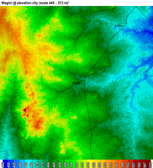
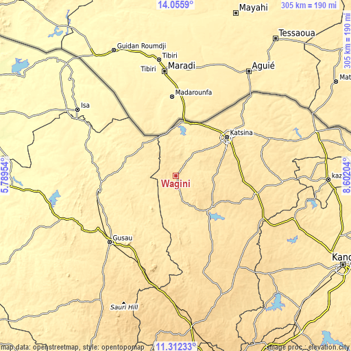
| \ | Map #1 | Map #2 | Topo.Map |
| Scale [m] | 464..545 m | 445..572 m | × |
| Scale [ft] | 1522..1788 ft | 1460..1877 ft | × |
| Average | 497.9 m = 1634 ft | 493.9 m = 1620 ft | × |
| Width | 9.53 km = 5.9 mi | 19.07 km = 11.8 mi | 305.1 km = 189.6 mi |
| Height | 9.53 km = 5.9 mi | 19.07 km = 11.8 mi | 305.1 km = 189.6 mi |
| ↑Max Latitude | 12.730679° | 12.77354° | 14.0559° |
| Latitude at center | 12.68781° | 12.68781° | 12.68781° |
| ↓Min Latitude | 12.644934° | 12.602051° | 11.31233° |
| ← Min Longitude | 7.151845° | 7.107899° | 5.78954° |
| Longitude center | 7.19579° | 7.19579° | 7.19579° |
| →Max Longitude | 7.239735° | 7.283681° | 8.60204° |
Nearby cities:
Cities around Wagini sort by population:
• Katsina elevation 519 m
55.4 km,  52°
52°
• Jibia 409 m
45.3 km,  4°
4°
• Runka 489 m
29.4 km,  155°
155°
• Dutsin-Ma 544 m
41.8 km,  128°
128°
• Ruma 502 m
19.9 km,  12°
12°
• Batsari 471 m
9.4 km,  37°
37°
• Batagarawa 532 m
50.7 km,  61°
61°
• Dan Musa 492 m
49.7 km, 162°
• Zurmi 397 m
45.7 km,  282°
282°
• Safana 509 m
38.9 km,  142°
142°
• Birnin Magaji 428 m
35.7 km,  246°
246°
• Kurfi 532 m
31.4 km,  94°
94°
Multilingual:
 En español:
Wagini elevación 488 m.
 En France:
Wagini élévation 488 m.


Sources and notes:
- [note 1] Map square and city borders are not equal. Map elevation data is calculated only from area inside that square.
- [src 1] Elevation data from geonames database provided with same terms of usage.
- [src 2] The elevation map of Wagini is generated using elevation data from NASA's 3 arcsec (90m) resolution SRTM data.
- [src 3] Base (background) map © OpenStreetMap contributors tiles are generated by Geofabrik and OpenTopoMap.
Copyright & License:
This Wagini Elevation Map is licensed under CC BY-SA. You may reuse any part from this page, if you give a proper credit by linking to this URL:
 More info on terms of use page.