Espinal elevation
Espinal (Veracruz), Mexico elevation is 93 meters and Espinal elevation in feet is 305 ft above sea level [src 1]. Espinal is a seat of a second-order administrative division (feature code) with elevation that is 1221 meters (4006 ft) smaller than average city elevation in Mexico.
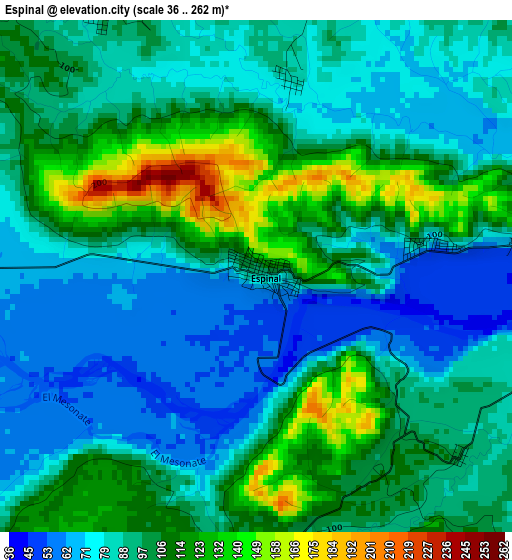
Below is the Elevation map of Espinal, which displays elevation range with different colors. Scale of the first map is from 36 to 262 m (118 to 860 ft) with average elevation of 94.5 meters (=310 ft) [note 1]
These maps also provides idea of topography and contour of this city, they are displayed at different zoom levels. More info about maps, scale and edge coordinates you can find below images.
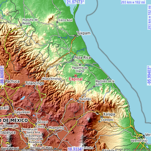
| \ | Map #1 | Topo.Map |
| Scale [m] | 36..262 m | × |
| Scale [ft] | 118..860 ft | × |
| Average | 94.5 m = 310 ft | × |
| Width | 9.17 km = 5.7 mi | 293.4 km = 182.3 mi |
| Height | 9.17 km = 5.7 mi | 293.4 km = 182.3 mi |
| ↑Max Latitude | 20.299391° | 21.57173° |
| Latitude at center | 20.25817° | 20.25817° |
| ↓Min Latitude | 20.216938° | 18.9334° |
| ← Min Longitude | -97.444225° | -98.80653° |
| Longitude center | -97.40028° | -97.40028° |
| →Max Longitude | -97.356335° | -95.99403° |
Nearby cities:
Cities around Espinal sort by population:
• Agua Dulce elevation 38 m
16.2 km,  43°
43°
• El Chote 72 m
17 km,  20°
20°
• Entabladero 95 m
15.8 km,  276°
276°
• Pueblillo 89 m
15.1 km,  91°
91°
• Buena Vista 127 m
15.5 km,  201°
201°
• Paso del Correo 36 m
14.8 km,  64°
64°
• El Chacal 92 m
7.4 km,  237°
237°
• Paso de Valencia 58 m
7.1 km,  77°
77°
• Santa Isabel 113 m
15.3 km, 241°
• Sabanas de Xalostoc 103 m
14.6 km,  254°
254°
• Tenampulco 232 m
9.8 km,  182°
182°
• El Arenal 82 m
12 km,  266°
266°
Multilingual:
 En español:
Espinal elevación 93 m.
 En France:
Espinal élévation 93 m.


Sources and notes:
- [note 1] Map square and city borders are not equal. Map elevation data is calculated only from area inside that square.
- [src 1] Elevation data from geonames database provided with same terms of usage.
- [src 2] The elevation map of Espinal is generated using elevation data from NASA's 3 arcsec (90m) resolution SRTM data.
- [src 3] Base (background) map © OpenStreetMap contributors tiles are generated by Geofabrik and OpenTopoMap.
Copyright & License:
This Espinal Elevation Map is licensed under CC BY-SA. You may reuse any part from this page, if you give a proper credit by linking to this URL:
 More info on terms of use page.