Pueblillo elevation
Pueblillo (Veracruz, Papantla), Mexico elevation is 89 meters and Pueblillo elevation in feet is 292 ft above sea level [src 1]. Pueblillo is a populated place (feature code) with elevation that is 1225 meters (4019 ft) smaller than average city elevation in Mexico.
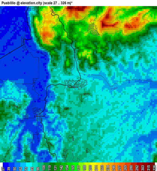
Below is the Elevation map of Pueblillo, which displays elevation range with different colors. Scale of the first map is from 27 to 326 m (89 to 1070 ft) with average elevation of 96.9 meters (=318 ft) [note 1]
These maps also provides idea of topography and contour of this city, they are displayed at different zoom levels. More info about maps, scale and edge coordinates you can find below images.
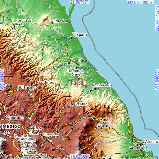
| \ | Map #1 | Topo.Map |
| Scale [m] | 27..326 m | × |
| Scale [ft] | 89..1070 ft | × |
| Average | 96.9 m = 318 ft | × |
| Width | 9.17 km = 5.7 mi | 293.4 km = 182.3 mi |
| Height | 9.17 km = 5.7 mi | 293.4 km = 182.3 mi |
| ↑Max Latitude | 20.295602° | 21.56797° |
| Latitude at center | 20.25438° | 20.25438° |
| ↓Min Latitude | 20.213147° | 18.92958° |
| ← Min Longitude | -97.299175° | -98.66148° |
| Longitude center | -97.25523° | -97.25523° |
| →Max Longitude | -97.211285° | -95.84898° |
Nearby cities:
Cities around Pueblillo sort by population:
• Agua Dulce elevation 38 m
12.7 km,  341°
341°
• El Chote 72 m
18.8 km,  330°
330°
• San José Acateno 141 m
14.5 km,  161°
161°
• Espinal 93 m
15.1 km,  271°
271°
• Carrillo Puerto 32 m
19.9 km,  23°
23°
• Emiliano Zapata 58 m
15.8 km,  27°
27°
• La Palma 91 m
21.3 km,  113°
113°
• El Remolino 108 m
15.7 km, 16°
• Paso del Correo 36 m
7.1 km,  345°
345°
• Paso de Valencia 58 m
8.4 km,  283°
283°
• Tenampulco 232 m
18.2 km,  239°
239°
• Manantiales 96 m
17.6 km,  120°
120°
Multilingual:
 En español:
Pueblillo elevación 89 m.
 En France:
Pueblillo élévation 89 m.
 Auf Deutsch:
Pueblillo höhe über dem Meeresspiegel ist 89 m.

Sources and notes:
- [note 1] Map square and city borders are not equal. Map elevation data is calculated only from area inside that square.
- [src 1] Elevation data from geonames database provided with same terms of usage.
- [src 2] The elevation map of Pueblillo is generated using elevation data from NASA's 3 arcsec (90m) resolution SRTM data.
- [src 3] Base (background) map © OpenStreetMap contributors tiles are generated by Geofabrik and OpenTopoMap.
Copyright & License:
This Pueblillo Elevation Map is licensed under CC BY-SA. You may reuse any part from this page, if you give a proper credit by linking to this URL:
 More info on terms of use page.