El Chote elevation
El Chote (Veracruz, Papantla), Mexico elevation is 72 meters and El Chote elevation in feet is 236 ft above sea level [src 1]. El Chote is a populated place (feature code) with elevation that is 1242 meters (4075 ft) smaller than average city elevation in Mexico.
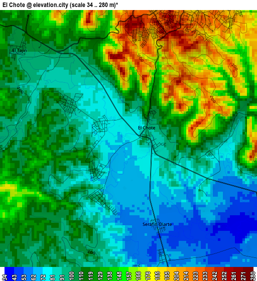
Below is the Elevation map of El Chote, which displays elevation range with different colors. Scale of the first map is from 34 to 280 m (112 to 919 ft) with average elevation of 116.3 meters (=382 ft) [note 1]
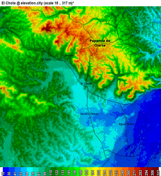
These maps also provides idea of topography and contour of this city, they are displayed at different zoom levels. More info about maps, scale and edge coordinates you can find below images.
| \ | Map #1 | Map #2 | Topo.Map |
| Scale [m] | 34..280 m | 18..317 m | × |
| Scale [ft] | 112..919 ft | 59..1040 ft | × |
| Average | 116.3 m = 382 ft | 117.2 m = 385 ft | × |
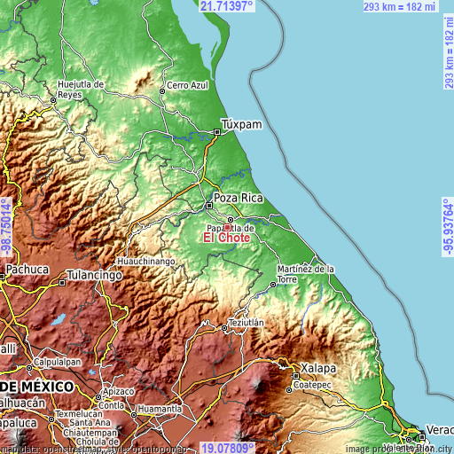
| Width | 9.16 km = 5.7 mi | 18.32 km = 11.4 mi | 293.1 km = 182.1 mi |
| Height | 9.16 km = 5.7 mi | 18.32 km = 11.4 mi | 293.1 km = 182.1 mi |
| ↑Max Latitude | 20.442853° | 20.484025° | 21.71397° |
| Latitude at center | 20.40167° | 20.40167° | 20.40167° |
| ↓Min Latitude | 20.360476° | 20.319271° | 19.07809° |
| ← Min Longitude | -97.387835° | -97.431781° | -98.75014° |
| Longitude center | -97.34389° | -97.34389° | -97.34389° |
| →Max Longitude | -97.299945° | -97.255999° | -95.93764° |
Nearby cities:
Cities around El Chote sort by population:
• Papantla de Olarte elevation 184 m
5.4 km,  21°
21°
• Coatzintla 77 m
16.1 km,  306°
306°
• Agua Dulce 38 m
6.8 km,  128°
128°
• Arroyo del Maíz Uno 111 m
16.8 km,  333°
333°
• Manuel María Contreras 104 m
15.3 km,  288°
288°
• Emiliano Zapata 58 m
16.8 km,  98°
98°
• Congregación el Tajín 105 m
5.1 km, 309°
• El Remolino 108 m
13.8 km, 95°
• Paso del Correo 36 m
12.1 km,  141°
141°
• Paso de Valencia 58 m
14.5 km,  175°
175°
• Polutla 144 m
16.6 km,  32°
32°
• Escolín de Olarte 139 m
13.6 km,  322°
322°
Multilingual:
 En español:
El Chote elevación 72 m.
 En France:
El Chote élévation 72 m.


Sources and notes:
- [note 1] Map square and city borders are not equal. Map elevation data is calculated only from area inside that square.
- [src 1] Elevation data from geonames database provided with same terms of usage.
- [src 2] The elevation map of El Chote is generated using elevation data from NASA's 3 arcsec (90m) resolution SRTM data.
- [src 3] Base (background) map © OpenStreetMap contributors tiles are generated by Geofabrik and OpenTopoMap.
Copyright & License:
This El Chote Elevation Map is licensed under CC BY-SA. You may reuse any part from this page, if you give a proper credit by linking to this URL:
 More info on terms of use page.