La Herradura elevation
La Herradura (State of Mexico, Tenango del Valle), Mexico elevation is 2595 meters and La Herradura elevation in feet is 8514 ft above sea level [src 1]. La Herradura is a populated place (feature code) with elevation that is 1281 meters (4203 ft) bigger than average city elevation in Mexico.
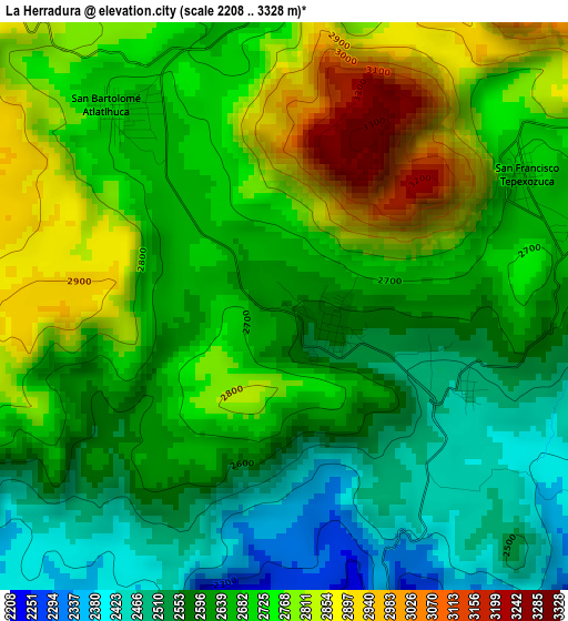
Below is the Elevation map of La Herradura, which displays elevation range with different colors. Scale of the first map is from 2208 to 3328 m (7244 to 10919 ft) with average elevation of 2676.8 meters (=8782 ft) [note 1]
These maps also provides idea of topography and contour of this city, they are displayed at different zoom levels. More info about maps, scale and edge coordinates you can find below images.
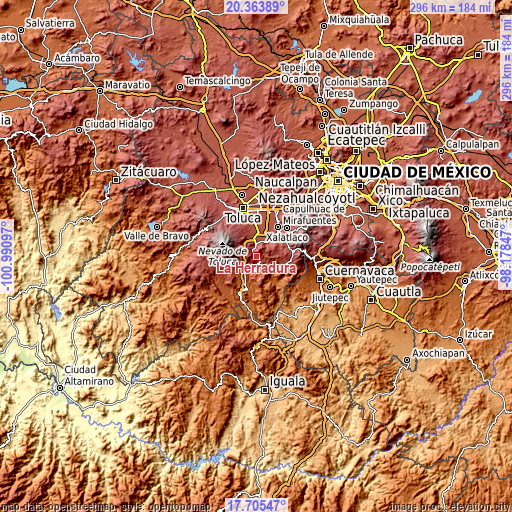
| \ | Map #1 | Topo.Map |
| Scale [m] | 2208..3328 m | × |
| Scale [ft] | 7244..10919 ft | × |
| Average | 2676.8 m = 8782 ft | × |
| Width | 9.24 km = 5.7 mi | 295.6 km = 183.7 mi |
| Height | 9.24 km = 5.7 mi | 295.6 km = 183.7 mi |
| ↑Max Latitude | 19.081536° | 20.36389° |
| Latitude at center | 19.04° | 19.04° |
| ↓Min Latitude | 18.998454° | 17.70547° |
| ← Min Longitude | -99.628665° | -100.99097° |
| Longitude center | -99.58472° | -99.58472° |
| →Max Longitude | -99.540775° | -98.17847° |
Nearby cities:
Cities around La Herradura sort by population:
• Tenango de Arista elevation 2610 m
7.2 km,  355°
355°
• San Bartolomé Atlatlahuca 2683 m
4.2 km,  321°
321°
• San Pedro Zictepec 2572 m
0.8 km,  117°
117°
• Joquicingo 2635 m
5.5 km,  77°
77°
• San Juan Xochiaca 2407 m
5.6 km, 121°
• San Francisco Tepexoxica 2685 m
4.5 km,  59°
59°
• San Martín Coapaxtongo 2210 m
5.3 km,  163°
163°
• San Gabriel Zepayautla 2465 m
4.6 km,  131°
131°
• San Simonito 2125 m
7.2 km,  138°
138°
• Chalchihuapan 2060 m
7.1 km,  171°
171°
• El Coloso 2654 m
6.6 km,  347°
347°
• Maxtleca de Galeana 2486 m
3.1 km,  113°
113°
Multilingual:
 En español:
La Herradura elevación 2595 m.
 En France:
La Herradura élévation 2595 m.
 Auf Deutsch:
La Herradura höhe über dem Meeresspiegel ist 2595 m.

Sources and notes:
- [note 1] Map square and city borders are not equal. Map elevation data is calculated only from area inside that square.
- [src 1] Elevation data from geonames database provided with same terms of usage.
- [src 2] The elevation map of La Herradura is generated using elevation data from NASA's 3 arcsec (90m) resolution SRTM data.
- [src 3] Base (background) map © OpenStreetMap contributors tiles are generated by Geofabrik and OpenTopoMap.
Copyright & License:
This La Herradura Elevation Map is licensed under CC BY-SA. You may reuse any part from this page, if you give a proper credit by linking to this URL:
 More info on terms of use page.