San Gabriel Zepayautla elevation
San Gabriel Zepayautla (State of Mexico, Tenancingo), Mexico elevation is 2465 meters and San Gabriel Zepayautla elevation in feet is 8087 ft above sea level [src 1]. San Gabriel Zepayautla is a populated place (feature code) with elevation that is 1151 meters (3776 ft) bigger than average city elevation in Mexico.
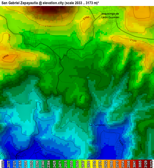
Below is the Elevation map of San Gabriel Zepayautla, which displays elevation range with different colors. Scale of the first map is from 2033 to 3173 m (6670 to 10410 ft) with average elevation of 2440.8 meters (=8008 ft) [note 1]
These maps also provides idea of topography and contour of this city, they are displayed at different zoom levels. More info about maps, scale and edge coordinates you can find below images.
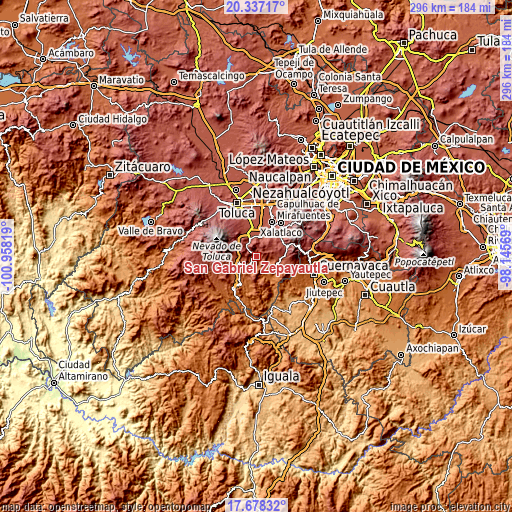
| \ | Map #1 | Topo.Map |
| Scale [m] | 2033..3173 m | × |
| Scale [ft] | 6670..10410 ft | × |
| Average | 2440.8 m = 8008 ft | × |
| Width | 9.24 km = 5.7 mi | 295.6 km = 183.7 mi |
| Height | 9.24 km = 5.7 mi | 295.7 km = 183.7 mi |
| ↑Max Latitude | 19.054603° | 20.33717° |
| Latitude at center | 19.01306° | 19.01306° |
| ↓Min Latitude | 18.971507° | 17.67832° |
| ← Min Longitude | -99.595885° | -100.95819° |
| Longitude center | -99.55194° | -99.55194° |
| →Max Longitude | -99.507995° | -98.14569° |
Nearby cities:
Cities around San Gabriel Zepayautla sort by population:
• San Pedro Zictepec elevation 2572 m
3.8 km,  314°
314°
• Joquicingo 2635 m
4.6 km,  24°
24°
• San Juan Xochiaca 2407 m
1.3 km,  87°
87°
• San Miguel Tecomatlán 2087 m
4.6 km,  147°
147°
• San Francisco Tepexoxica 2685 m
5.3 km,  4°
4°
• San Martín Coapaxtongo 2210 m
2.8 km,  222°
222°
• San Simón el Alto 2412 m
5.4 km,  109°
109°
• Colonia San Ramón 2033 m
5.4 km,  203°
203°
• San Simonito 2125 m
2.7 km, 152°
• Chalchihuapan 2060 m
4.7 km,  210°
210°
• Maxtleca de Galeana 2486 m
1.8 km,  342°
342°
• La Herradura 2595 m
4.6 km, 311°
Multilingual:
 En español:
San Gabriel Zepayautla elevación 2465 m.
 En France:
San Gabriel Zepayautla élévation 2465 m.
 Auf Deutsch:
San Gabriel Zepayautla höhe über dem Meeresspiegel ist 2465 m.
 На русском:
San Gabriel Zepayautla высота над уровнем моря 2465 м
Sources and notes:
- [note 1] Map square and city borders are not equal. Map elevation data is calculated only from area inside that square.
- [src 1] Elevation data from geonames database provided with same terms of usage.
- [src 2] The elevation map of San Gabriel Zepayautla is generated using elevation data from NASA's 3 arcsec (90m) resolution SRTM data.
- [src 3] Base (background) map © OpenStreetMap contributors tiles are generated by Geofabrik and OpenTopoMap.
Copyright & License:
This San Gabriel Zepayautla Elevation Map is licensed under CC BY-SA. You may reuse any part from this page, if you give a proper credit by linking to this URL:
 More info on terms of use page.