Tenango de Arista elevation
Tenango de Arista (State of Mexico, Tenango del Valle), Mexico elevation is 2610 meters and Tenango de Arista elevation in feet is 8563 ft above sea level [src 1]. Tenango de Arista is a seat of a second-order administrative division (feature code) with elevation that is 1296 meters (4252 ft) bigger than average city elevation in Mexico.
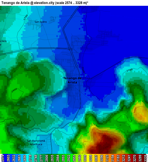
Below is the Elevation map of Tenango de Arista, which displays elevation range with different colors. Scale of the first map is from 2574 to 3328 m (8445 to 10919 ft) with average elevation of 2726.2 meters (=8944 ft) [note 1]
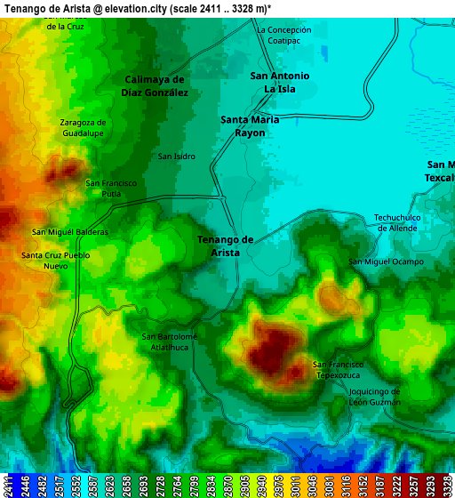
These maps also provides idea of topography and contour of this city, they are displayed at different zoom levels. More info about maps, scale and edge coordinates you can find below images.
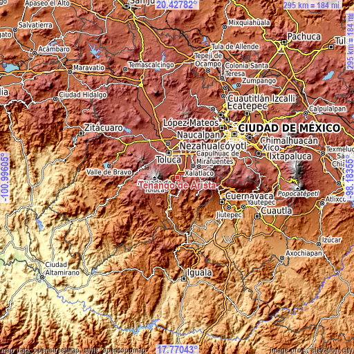
| \ | Map #1 | Map #2 | Topo.Map |
| Scale [m] | 2574..3328 m | 2411..3328 m | × |
| Scale [ft] | 8445..10919 ft | 7910..10919 ft | × |
| Average | 2726.2 m = 8944 ft | 2742.2 m = 8997 ft | × |
| Width | 9.23 km = 5.7 mi | 18.47 km = 11.5 mi | 295.5 km = 183.6 mi |
| Height | 9.23 km = 5.7 mi | 18.47 km = 11.5 mi | 295.5 km = 183.6 mi |
| ↑Max Latitude | 19.14598° | 19.187489° | 20.42782° |
| Latitude at center | 19.10446° | 19.10446° | 19.10446° |
| ↓Min Latitude | 19.06293° | 19.021389° | 17.77043° |
| ← Min Longitude | -99.633745° | -99.677691° | -100.99605° |
| Longitude center | -99.5898° | -99.5898° | -99.5898° |
| →Max Longitude | -99.545855° | -99.501909° | -98.18355° |
Nearby cities:
Cities around Tenango de Arista sort by population:
• Santa María Rayón elevation 2595 m
5 km,  12°
12°
• Santa María Jajalpa 2583 m
5.7 km,  81°
81°
• San Bartolomé Atlatlahuca 2683 m
4.4 km,  208°
208°
• San Miguel Balderas 2857 m
6.5 km,  274°
274°
• San Francisco Putla 2749 m
5.5 km,  298°
298°
• San Francisco Tepexoxica 2685 m
6.6 km,  137°
137°
• San Diego la Huerta 2778 m
6.4 km,  314°
314°
• San Francisco Tetetla 2635 m
1.8 km,  318°
318°
• San Juan la Isla 2584 m
3.5 km,  34°
34°
• Monte Calvario 2687 m
0.6 km, 269°
• Colonia Emiliano Zapata 2597 m
2.4 km,  23°
23°
• El Coloso 2654 m
1.1 km,  228°
228°
Multilingual:
 En español:
Tenango de Arista elevación 2610 m.
 En France:
Tenango de Arista élévation 2610 m.
 Auf Deutsch:
Tenango de Arista höhe über dem Meeresspiegel ist 2610 m.
 На русском:
Tenango de Arista высота над уровнем моря 2610 м
Sources and notes:
- [note 1] Map square and city borders are not equal. Map elevation data is calculated only from area inside that square.
- [src 1] Elevation data from geonames database provided with same terms of usage.
- [src 2] The elevation map of Tenango de Arista is generated using elevation data from NASA's 3 arcsec (90m) resolution SRTM data.
- [src 3] Base (background) map © OpenStreetMap contributors tiles are generated by Geofabrik and OpenTopoMap.
Copyright & License:
This Tenango de Arista Elevation Map is licensed under CC BY-SA. You may reuse any part from this page, if you give a proper credit by linking to this URL:
 More info on terms of use page.