Joconoxtle (La Tuna) elevation
Joconoxtle (La Tuna) (Jalisco, Ocotlán), Mexico elevation is 1554 meters and Joconoxtle (La Tuna) elevation in feet is 5098 ft above sea level [src 1]. Joconoxtle (La Tuna) is a populated place (feature code) with elevation that is 240 meters (787 ft) bigger than average city elevation in Mexico.
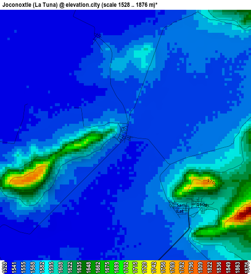
Below is the Elevation map of Joconoxtle (La Tuna), which displays elevation range with different colors. Scale of the first map is from 1528 to 1876 m (5013 to 6155 ft) with average elevation of 1564.5 meters (=5133 ft) [note 1]
These maps also provides idea of topography and contour of this city, they are displayed at different zoom levels. More info about maps, scale and edge coordinates you can find below images.
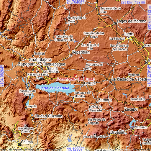
| \ | Map #1 | Topo.Map |
| Scale [m] | 1528..1876 m | × |
| Scale [ft] | 5013..6155 ft | × |
| Average | 1564.5 m = 5133 ft | × |
| Width | 9.16 km = 5.7 mi | 293 km = 182.1 mi |
| Height | 9.16 km = 5.7 mi | 293 km = 182.1 mi |
| ↑Max Latitude | 20.49339° | 21.76408° |
| Latitude at center | 20.45222° | 20.45222° |
| ↓Min Latitude | 20.411039° | 19.12907° |
| ← Min Longitude | -102.720335° | -104.08264° |
| Longitude center | -102.67639° | -102.67639° |
| →Max Longitude | -102.632445° | -101.27014° |
Nearby cities:
Cities around Joconoxtle (La Tuna) sort by population:
• Ocotlán elevation 1532 m
14.8 km,  223°
223°
• Tototlán 1547 m
15.7 km,  309°
309°
• San Miguel de la Paz 1552 m
9.2 km,  171°
171°
• San Martín de Zula 1535 m
7.2 km,  228°
228°
• El Nacimiento 1589 m
16.2 km,  53°
53°
• Milpillas 1567 m
15.8 km,  69°
69°
• San Francisco de Rivas 1551 m
16.5 km,  138°
138°
• San Antonio de Fernández 1606 m
12.7 km,  28°
28°
• Otatlán 1552 m
13.3 km,  264°
264°
• San José de las Moras 1552 m
16.5 km,  148°
148°
• San Vicente 1583 m
3.5 km, 139°
• Nuevo Refugio de Afuera (Nuevo Refugio) 1542 m
11.2 km,  343°
343°
Multilingual:
 En español:
Joconoxtle (La Tuna) elevación 1554 m.
 En France:
Joconoxtle (La Tuna) élévation 1554 m.
 Auf Deutsch:
Joconoxtle (La Tuna) höhe über dem Meeresspiegel ist 1554 m.
 На русском:
Joconoxtle (La Tuna) высота над уровнем моря 1554 м
Sources and notes:
- [note 1] Map square and city borders are not equal. Map elevation data is calculated only from area inside that square.
- [src 1] Elevation data from geonames database provided with same terms of usage.
- [src 2] The elevation map of Joconoxtle (La Tuna) is generated using elevation data from NASA's 3 arcsec (90m) resolution SRTM data.
- [src 3] Base (background) map © OpenStreetMap contributors tiles are generated by Geofabrik and OpenTopoMap.
Copyright & License:
This Joconoxtle (La Tuna) Elevation Map is licensed under CC BY-SA. You may reuse any part from this page, if you give a proper credit by linking to this URL:
 More info on terms of use page.