Milpillas elevation
Milpillas (Jalisco, Atotonilco el Alto), Mexico elevation is 1567 meters and Milpillas elevation in feet is 5141 ft above sea level [src 1]. Milpillas is a populated place (feature code) with elevation that is 253 meters (830 ft) bigger than average city elevation in Mexico.
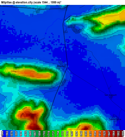
Below is the Elevation map of Milpillas, which displays elevation range with different colors. Scale of the first map is from 1544 to 1999 m (5066 to 6558 ft) with average elevation of 1615.8 meters (=5301 ft) [note 1]
These maps also provides idea of topography and contour of this city, they are displayed at different zoom levels. More info about maps, scale and edge coordinates you can find below images.
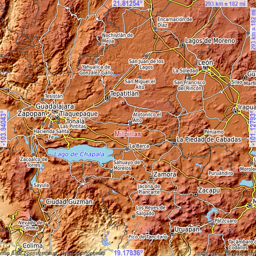
| \ | Map #1 | Topo.Map |
| Scale [m] | 1544..1999 m | × |
| Scale [ft] | 5066..6558 ft | × |
| Average | 1615.8 m = 5301 ft | × |
| Width | 9.15 km = 5.7 mi | 292.9 km = 182 mi |
| Height | 9.15 km = 5.7 mi | 292.9 km = 182 mi |
| ↑Max Latitude | 20.542267° | 21.81254° |
| Latitude at center | 20.50111° | 20.50111° |
| ↓Min Latitude | 20.459942° | 19.17836° |
| ← Min Longitude | -102.578125° | -103.94043° |
| Longitude center | -102.53418° | -102.53418° |
| →Max Longitude | -102.490235° | -101.12793° |
Nearby cities:
Cities around Milpillas sort by population:
• Atotonilco el Alto elevation 1607 m
6.1 km,  25°
25°
• San Francisco de Asís 1966 m
11.1 km,  343°
343°
• Vistas del Maguey [Fraccionamiento] 1581 m
3.2 km,  20°
20°
• Portezuelo 1558 m
9.9 km,  170°
170°
• Villa de García Márquez 1554 m
8.8 km,  152°
152°
• Margaritas 1548 m
8.2 km,  130°
130°
• San José Casas Caídas 1542 m
13.2 km, 132°
• El Nacimiento 1589 m
4.5 km, 336°
• San Antonio de Fernández 1606 m
10.4 km,  303°
303°
• Ojo de Agua de Morán 1987 m
10.4 km,  2°
2°
• San Vicente 1583 m
14.9 km,  237°
237°
• Joconoxtle (La Tuna) 1554 m
15.8 km,  249°
249°
Multilingual:
 En español:
Milpillas elevación 1567 m.
 En France:
Milpillas élévation 1567 m.
 Auf Deutsch:
Milpillas höhe über dem Meeresspiegel ist 1567 m.

Sources and notes:
- [note 1] Map square and city borders are not equal. Map elevation data is calculated only from area inside that square.
- [src 1] Elevation data from geonames database provided with same terms of usage.
- [src 2] The elevation map of Milpillas is generated using elevation data from NASA's 3 arcsec (90m) resolution SRTM data.
- [src 3] Base (background) map © OpenStreetMap contributors tiles are generated by Geofabrik and OpenTopoMap.
Copyright & License:
This Milpillas Elevation Map is licensed under CC BY-SA. You may reuse any part from this page, if you give a proper credit by linking to this URL:
 More info on terms of use page.