Tototlán elevation
Tototlán (Jalisco), Mexico elevation is 1547 meters and Tototlán elevation in feet is 5075 ft above sea level [src 1]. Tototlán is a seat of a second-order administrative division (feature code) with elevation that is 233 meters (764 ft) bigger than average city elevation in Mexico.
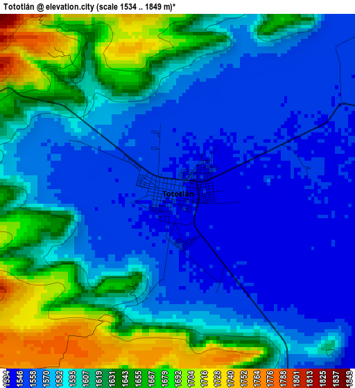
Below is the Elevation map of Tototlán, which displays elevation range with different colors. Scale of the first map is from 1534 to 1849 m (5033 to 6066 ft) with average elevation of 1599.8 meters (=5249 ft) [note 1]
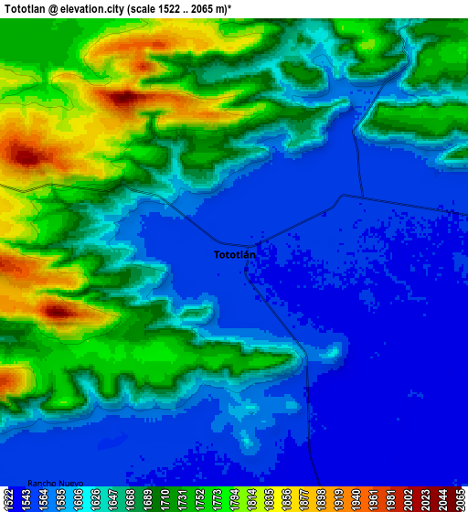
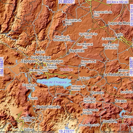
These maps also provides idea of topography and contour of this city, they are displayed at different zoom levels. More info about maps, scale and edge coordinates you can find below images.
| \ | Map #1 | Map #2 | Topo.Map |
| Scale [m] | 1534..1849 m | 1522..2065 m | × |
| Scale [ft] | 5033..6066 ft | 4993..6775 ft | × |
| Average | 1599.8 m = 5249 ft | 1650.4 m = 5415 ft | × |
| Width | 9.15 km = 5.7 mi | 18.3 km = 11.4 mi | 292.8 km = 181.9 mi |
| Height | 9.15 km = 5.7 mi | 18.3 km = 11.4 mi | 292.8 km = 181.9 mi |
| ↑Max Latitude | 20.583315° | 20.62445° | 21.85323° |
| Latitude at center | 20.54217° | 20.54217° | 20.54217° |
| ↓Min Latitude | 20.501013° | 20.459846° | 19.21977° |
| ← Min Longitude | -102.836165° | -102.880111° | -104.19847° |
| Longitude center | -102.79222° | -102.79222° | -102.79222° |
| →Max Longitude | -102.748275° | -102.704329° | -101.38597° |
Nearby cities:
Cities around Tototlán sort by population:
• Ocotlán elevation 1532 m
20.9 km,  174°
174°
• Zapotlán del Rey 1553 m
16.3 km,  238°
238°
• Santa Cruz el Grande 1533 m
20 km,  201°
201°
• Capilla de Milpillas 1823 m
14.5 km,  338°
338°
• San Martín de Zula 1535 m
16.2 km,  155°
155°
• Ahuatlán 1544 m
17 km,  215°
215°
• San Antonio de Fernández 1606 m
18.2 km,  86°
86°
• Otatlán 1552 m
11.3 km,  186°
186°
• San Luis de Agua Caliente 1532 m
18 km, 190°
• San Vicente 1583 m
19.1 km,  131°
131°
• Joconoxtle (La Tuna) 1554 m
15.7 km, 129°
• Nuevo Refugio de Afuera (Nuevo Refugio) 1542 m
8.9 km, 85°
Multilingual:
 En español:
Tototlán elevación 1547 m.
 En France:
Tototlán élévation 1547 m.
 Auf Deutsch:
Tototlán höhe über dem Meeresspiegel ist 1547 m.

Sources and notes:
- [note 1] Map square and city borders are not equal. Map elevation data is calculated only from area inside that square.
- [src 1] Elevation data from geonames database provided with same terms of usage.
- [src 2] The elevation map of Tototlán is generated using elevation data from NASA's 3 arcsec (90m) resolution SRTM data.
- [src 3] Base (background) map © OpenStreetMap contributors tiles are generated by Geofabrik and OpenTopoMap.
Copyright & License:
This Tototlán Elevation Map is licensed under CC BY-SA. You may reuse any part from this page, if you give a proper credit by linking to this URL:
 More info on terms of use page.