Nexpan elevation
Nexpan (Puebla, Hueyapan), Mexico elevation is 1627 meters and Nexpan elevation in feet is 5338 ft above sea level [src 1]. Nexpan is a populated place (feature code) with elevation that is 313 meters (1027 ft) bigger than average city elevation in Mexico.
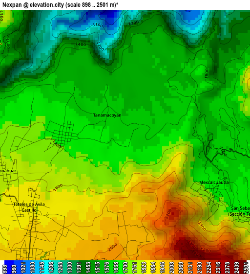
Below is the Elevation map of Nexpan, which displays elevation range with different colors. Scale of the first map is from 898 to 2501 m (2946 to 8205 ft) with average elevation of 1678.6 meters (=5507 ft) [note 1]
These maps also provides idea of topography and contour of this city, they are displayed at different zoom levels. More info about maps, scale and edge coordinates you can find below images.
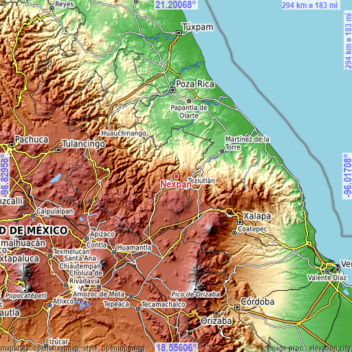
| \ | Map #1 | Topo.Map |
| Scale [m] | 898..2501 m | × |
| Scale [ft] | 2946..8205 ft | × |
| Average | 1678.6 m = 5507 ft | × |
| Width | 9.19 km = 5.7 mi | 294.1 km = 182.7 mi |
| Height | 9.19 km = 5.7 mi | 294.1 km = 182.7 mi |
| ↑Max Latitude | 19.92521° | 21.20068° |
| Latitude at center | 19.88389° | 19.88389° |
| ↓Min Latitude | 19.842559° | 18.55606° |
| ← Min Longitude | -97.467275° | -98.82958° |
| Longitude center | -97.42333° | -97.42333° |
| →Max Longitude | -97.379385° | -96.01708° |
Nearby cities:
Cities around Nexpan sort by population:
• Atempan elevation 1960 m
6.2 km,  216°
216°
• Hueyapán 1688 m
2.3 km,  266°
266°
• Yaonahuac 1792 m
4.7 km,  251°
251°
• San Acateno 1611 m
6 km,  99°
99°
• Teteles de Avila Castillo 1878 m
4.6 km,  230°
230°
• Tacopan 2061 m
5.2 km,  188°
188°
• San Sebastián 1729 m
6.4 km,  120°
120°
• Cala Sur 2096 m
5.7 km,  177°
177°
• Mexcalcuautla 1661 m
3.8 km, 120°
• Tanamacoyan 1622 m
1 km,  317°
317°
• Atzalán 2037 m
6.9 km,  198°
198°
• Cala Norte 1970 m
4 km, 179°
Multilingual:
 En español:
Nexpan elevación 1627 m.
 En France:
Nexpan élévation 1627 m.


Sources and notes:
- [note 1] Map square and city borders are not equal. Map elevation data is calculated only from area inside that square.
- [src 1] Elevation data from geonames database provided with same terms of usage.
- [src 2] The elevation map of Nexpan is generated using elevation data from NASA's 3 arcsec (90m) resolution SRTM data.
- [src 3] Base (background) map © OpenStreetMap contributors tiles are generated by Geofabrik and OpenTopoMap.
Copyright & License:
This Nexpan Elevation Map is licensed under CC BY-SA. You may reuse any part from this page, if you give a proper credit by linking to this URL:
 More info on terms of use page.