Atempan elevation
Atempan (Puebla), Mexico elevation is 1960 meters and Atempan elevation in feet is 6430 ft above sea level [src 1]. Atempan is a populated place (feature code) with elevation that is 646 meters (2119 ft) bigger than average city elevation in Mexico.
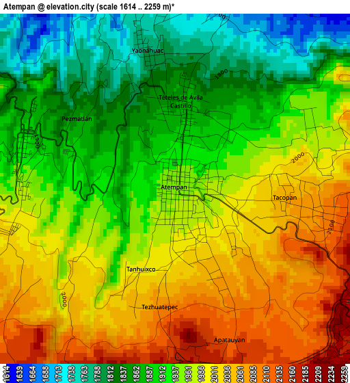
Below is the Elevation map of Atempan, which displays elevation range with different colors. Scale of the first map is from 1614 to 2259 m (5295 to 7411 ft) with average elevation of 1951.1 meters (=6401 ft) [note 1]
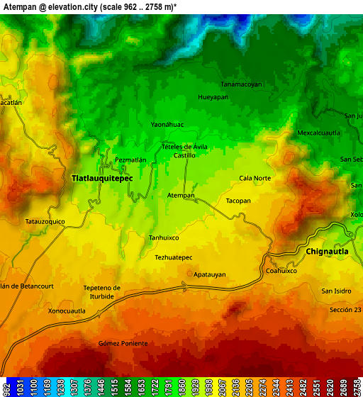
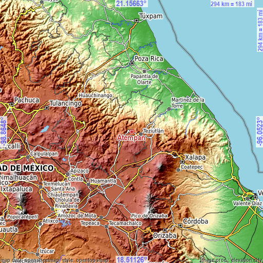
These maps also provides idea of topography and contour of this city, they are displayed at different zoom levels. More info about maps, scale and edge coordinates you can find below images.
| \ | Map #1 | Map #2 | Topo.Map |
| Scale [m] | 1614..2259 m | 962..2758 m | × |
| Scale [ft] | 5295..7411 ft | 3156..9049 ft | × |
| Average | 1951.1 m = 6401 ft | 2012.9 m = 6604 ft | × |
| Width | 9.19 km = 5.7 mi | 18.39 km = 11.4 mi | 294.1 km = 182.7 mi |
| Height | 9.19 km = 5.7 mi | 18.39 km = 11.4 mi | 294.2 km = 182.8 mi |
| ↑Max Latitude | 19.880782° | 19.922103° | 21.15663° |
| Latitude at center | 19.83945° | 19.83945° | 19.83945° |
| ↓Min Latitude | 19.798108° | 19.756754° | 18.51126° |
| ← Min Longitude | -97.502495° | -97.546441° | -98.8648° |
| Longitude center | -97.45855° | -97.45855° | -97.45855° |
| →Max Longitude | -97.414605° | -97.370659° | -96.0523° |
Nearby cities:
Cities around Atempan sort by population:
• Tlatlauquitepec elevation 1929 m
4.1 km,  282°
282°
• Ciudad de Tlatlauquitepec 1904 m
4.1 km,  291°
291°
• Yaonahuac 1792 m
3.6 km,  347°
347°
• Teteles de Avila Castillo 1878 m
2 km,  4°
4°
• Tacopan 2061 m
2.9 km,  94°
94°
• Cala Sur 2096 m
4 km,  100°
100°
• Tezhuatepec 2082 m
3.1 km,  187°
187°
• Apatauyan 2172 m
4.7 km,  161°
161°
• Atzalán 2037 m
2.2 km,  137°
137°
• Pezmatlán 1905 m
2.9 km, 285°
• Cala Norte 1970 m
3.8 km,  75°
75°
• Tanhuixco 1995 m
2.3 km,  203°
203°
Multilingual:
 En español:
Atempan elevación 1960 m.
 En France:
Atempan élévation 1960 m.
 Auf Deutsch:
Atempan höhe über dem Meeresspiegel ist 1960 m.

Sources and notes:
- [note 1] Map square and city borders are not equal. Map elevation data is calculated only from area inside that square.
- [src 1] Elevation data from geonames database provided with same terms of usage.
- [src 2] The elevation map of Atempan is generated using elevation data from NASA's 3 arcsec (90m) resolution SRTM data.
- [src 3] Base (background) map © OpenStreetMap contributors tiles are generated by Geofabrik and OpenTopoMap.
Copyright & License:
This Atempan Elevation Map is licensed under CC BY-SA. You may reuse any part from this page, if you give a proper credit by linking to this URL:
 More info on terms of use page.