Hueyapán elevation
Hueyapán (Puebla, Hueyapan), Mexico elevation is 1688 meters and Hueyapán elevation in feet is 5538 ft above sea level [src 1]. Hueyapán is a populated place (feature code) with elevation that is 374 meters (1227 ft) bigger than average city elevation in Mexico.
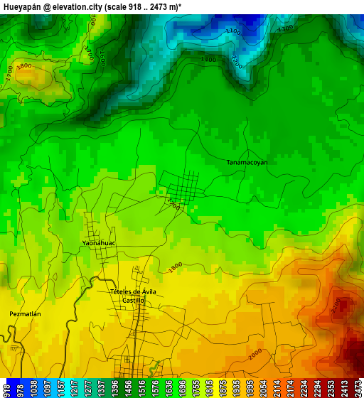
Below is the Elevation map of Hueyapán, which displays elevation range with different colors. Scale of the first map is from 918 to 2473 m (3012 to 8114 ft) with average elevation of 1699.9 meters (=5577 ft) [note 1]
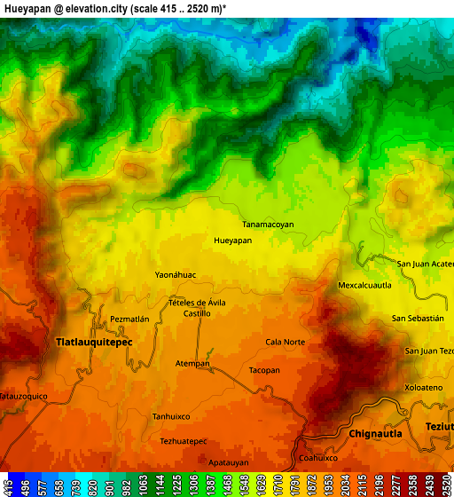
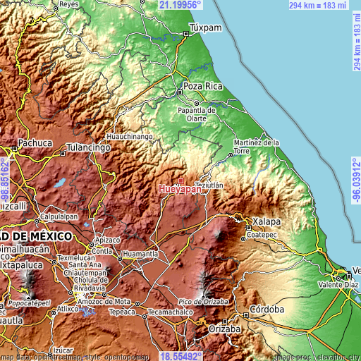
These maps also provides idea of topography and contour of this city, they are displayed at different zoom levels. More info about maps, scale and edge coordinates you can find below images.
| \ | Map #1 | Map #2 | Topo.Map |
| Scale [m] | 918..2473 m | 415..2520 m | × |
| Scale [ft] | 3012..8114 ft | 1362..8268 ft | × |
| Average | 1699.9 m = 5577 ft | 1655.8 m = 5432 ft | × |
| Width | 9.19 km = 5.7 mi | 18.38 km = 11.4 mi | 294.1 km = 182.7 mi |
| Height | 9.19 km = 5.7 mi | 18.38 km = 11.4 mi | 294.1 km = 182.7 mi |
| ↑Max Latitude | 19.92408° | 19.96539° | 21.19956° |
| Latitude at center | 19.88276° | 19.88276° | 19.88276° |
| ↓Min Latitude | 19.841429° | 19.800087° | 18.55492° |
| ← Min Longitude | -97.489315° | -97.533261° | -98.85162° |
| Longitude center | -97.44537° | -97.44537° | -97.44537° |
| →Max Longitude | -97.401425° | -97.357479° | -96.03912° |
Nearby cities:
Cities around Hueyapán sort by population:
• Ciudad de Tlatlauquitepec elevation 1904 m
6.2 km,  237°
237°
• Atempan 1960 m
5 km,  195°
195°
• Yaonahuac 1792 m
2.5 km, 238°
• Teteles de Avila Castillo 1878 m
3.1 km, 203°
• Tacopan 2061 m
5.2 km,  163°
163°
• Cala Sur 2096 m
6.1 km, 155°
• Mexcalcuautla 1661 m
5.9 km,  107°
107°
• Tanamacoyan 1622 m
1.9 km,  62°
62°
• Atzalán 2037 m
6.5 km,  178°
178°
• Pezmatlán 1905 m
5.8 km,  226°
226°
• Cala Norte 1970 m
4.5 km,  149°
149°
• Nexpan 1627 m
2.3 km,  86°
86°
Multilingual:
 En español:
Hueyapán elevación 1688 m.
 En France:
Hueyapán élévation 1688 m.
 Auf Deutsch:
Hueyapán höhe über dem Meeresspiegel ist 1688 m.

Sources and notes:
- [note 1] Map square and city borders are not equal. Map elevation data is calculated only from area inside that square.
- [src 1] Elevation data from geonames database provided with same terms of usage.
- [src 2] The elevation map of Hueyapán is generated using elevation data from NASA's 3 arcsec (90m) resolution SRTM data.
- [src 3] Base (background) map © OpenStreetMap contributors tiles are generated by Geofabrik and OpenTopoMap.
Copyright & License:
This Hueyapán Elevation Map is licensed under CC BY-SA. You may reuse any part from this page, if you give a proper credit by linking to this URL:
 More info on terms of use page.