Turuachi elevation
Turuachi (Chihuahua, Guadalupe y Calvo), Mexico elevation is 2093 meters and Turuachi elevation in feet is 6867 ft above sea level [src 1]. Turuachi is a populated place (feature code) with elevation that is 779 meters (2556 ft) bigger than average city elevation in Mexico.
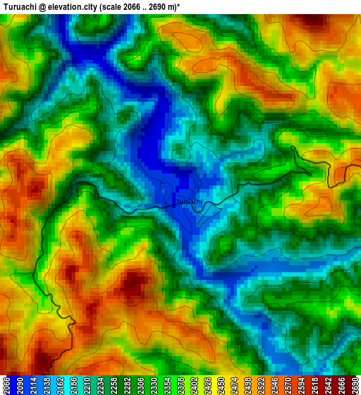
Below is the Elevation map of Turuachi, which displays elevation range with different colors. Scale of the first map is from 2066 to 2690 m (6778 to 8825 ft) with average elevation of 2336.4 meters (=7665 ft) [note 1]
These maps also provides idea of topography and contour of this city, they are displayed at different zoom levels. More info about maps, scale and edge coordinates you can find below images.
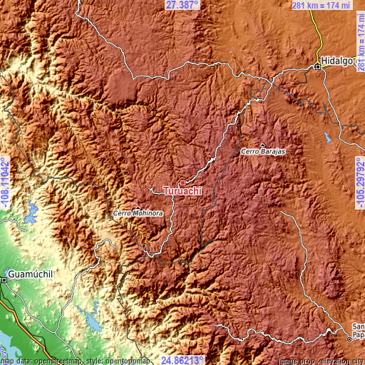
| \ | Map #1 | Topo.Map |
| Scale [m] | 2066..2690 m | × |
| Scale [ft] | 6778..8825 ft | × |
| Average | 2336.4 m = 7665 ft | × |
| Width | 8.77 km = 5.4 mi | 280.7 km = 174.4 mi |
| Height | 8.77 km = 5.4 mi | 280.8 km = 174.5 mi |
| ↑Max Latitude | 26.170837° | 27.387° |
| Latitude at center | 26.13139° | 26.13139° |
| ↓Min Latitude | 26.09193° | 24.86213° |
| ← Min Longitude | -106.748115° | -108.11042° |
| Longitude center | -106.70417° | -106.70417° |
| →Max Longitude | -106.660225° | -105.29792° |
Nearby cities:
Cities around Turuachi sort by population:
• Guachochi elevation 2398 m
85 km,  334°
334°
• Guadalupe y Calvo 2315 m
26.2 km,  260°
260°
• Baborigame 1985 m
65.3 km,  300°
300°
• Guanaceví 2080 m
77.9 km,  106°
106°
• Mariano Balleza 1568 m
98.1 km,  21°
21°
• Topia 1745 m
103.2 km,  172°
172°
• Ejido El Vergel 2733 m
49.5 km,  40°
40°
• Las Yerbitas [Aserradero] 2669 m
9.4 km,  232°
232°
• El Durazno 2351 m
76.8 km,  196°
196°
• El Tule 1569 m
111.4 km, 23°
• Canelas 1342 m
113.2 km, 171°
• Balleza 1574 m
97.8 km, 21°
Multilingual:
 En español:
Turuachi elevación 2093 m.
 En France:
Turuachi élévation 2093 m.
 Auf Deutsch:
Turuachi höhe über dem Meeresspiegel ist 2093 m.

Sources and notes:
- [note 1] Map square and city borders are not equal. Map elevation data is calculated only from area inside that square.
- [src 1] Elevation data from geonames database provided with same terms of usage.
- [src 2] The elevation map of Turuachi is generated using elevation data from NASA's 3 arcsec (90m) resolution SRTM data.
- [src 3] Base (background) map © OpenStreetMap contributors tiles are generated by Geofabrik and OpenTopoMap.
Copyright & License:
This Turuachi Elevation Map is licensed under CC BY-SA. You may reuse any part from this page, if you give a proper credit by linking to this URL:
 More info on terms of use page.