El Tule elevation
El Tule (Chihuahua), Mexico elevation is 1569 meters and El Tule elevation in feet is 5148 ft above sea level [src 1]. El Tule is a seat of a second-order administrative division (feature code) with elevation that is 255 meters (837 ft) bigger than average city elevation in Mexico.
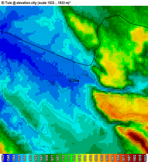
Below is the Elevation map of El Tule, which displays elevation range with different colors. Scale of the first map is from 1533 to 1933 m (5030 to 6342 ft) with average elevation of 1641.9 meters (=5387 ft) [note 1]
These maps also provides idea of topography and contour of this city, they are displayed at different zoom levels. More info about maps, scale and edge coordinates you can find below images.
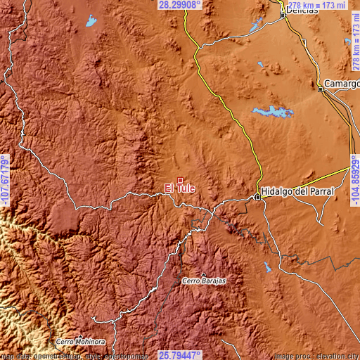
| \ | Map #1 | Topo.Map |
| Scale [m] | 1533..1933 m | × |
| Scale [ft] | 5030..6342 ft | × |
| Average | 1641.9 m = 5387 ft | × |
| Width | 8.7 km = 5.4 mi | 278.5 km = 173.1 mi |
| Height | 8.7 km = 5.4 mi | 278.5 km = 173.1 mi |
| ↑Max Latitude | 27.09289° | 28.29908° |
| Latitude at center | 27.05376° | 27.05376° |
| ↓Min Latitude | 27.014616° | 25.79447° |
| ← Min Longitude | -106.309485° | -107.67179° |
| Longitude center | -106.26554° | -106.26554° |
| →Max Longitude | -106.221595° | -104.85929° |
Nearby cities:
Cities around El Tule sort by population:
• Parral elevation 1722 m
60.9 km,  103°
103°
• Guachochi 2398 m
84.3 km,  252°
252°
• Santa Bárbara 1947 m
52.2 km,  122°
122°
• El Oro 1972 m
46.5 km, 117°
• Matamoros 1732 m
74.8 km, 115°
• Valle de Zaragoza 1357 m
63.2 km,  45°
45°
• Mariano Balleza 1568 m
13.7 km,  215°
215°
• Ejido El Vergel 2733 m
65.8 km,  190°
190°
• Nonoava 1643 m
65.8 km,  315°
315°
• Valle del Rosario 1477 m
29.6 km,  354°
354°
• Huejotitán 1654 m
8.7 km,  88°
88°
• Balleza 1574 m
14.1 km, 216°
Multilingual:
 En español:
El Tule elevación 1569 m.
 En France:
El Tule élévation 1569 m.
 Auf Deutsch:
El Tule höhe über dem Meeresspiegel ist 1569 m.

Sources and notes:
- [note 1] Map square and city borders are not equal. Map elevation data is calculated only from area inside that square.
- [src 1] Elevation data from geonames database provided with same terms of usage.
- [src 2] The elevation map of El Tule is generated using elevation data from NASA's 3 arcsec (90m) resolution SRTM data.
- [src 3] Base (background) map © OpenStreetMap contributors tiles are generated by Geofabrik and OpenTopoMap.
Copyright & License:
This El Tule Elevation Map is licensed under CC BY-SA. You may reuse any part from this page, if you give a proper credit by linking to this URL:
 More info on terms of use page.