El Durazno elevation
El Durazno (Durango, Tamazula), Mexico elevation is 2351 meters and El Durazno elevation in feet is 7713 ft above sea level [src 1]. El Durazno is a populated place (feature code) with elevation that is 1037 meters (3402 ft) bigger than average city elevation in Mexico.
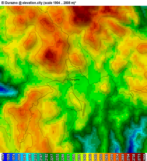
Below is the Elevation map of El Durazno, which displays elevation range with different colors. Scale of the first map is from 1904 to 2808 m (6247 to 9213 ft) with average elevation of 2414 meters (=7920 ft) [note 1]
These maps also provides idea of topography and contour of this city, they are displayed at different zoom levels. More info about maps, scale and edge coordinates you can find below images.
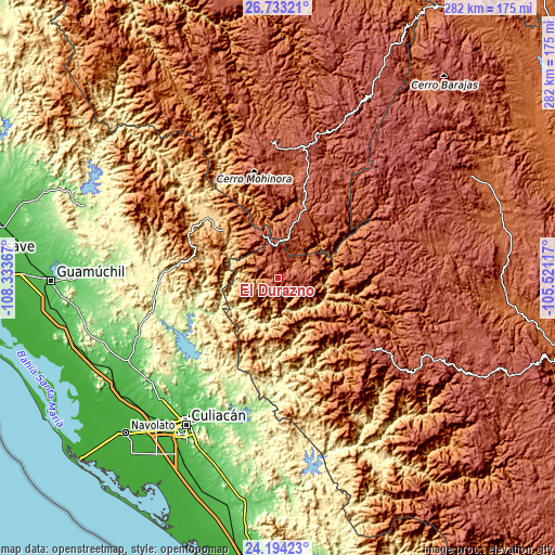
| \ | Map #1 | Topo.Map |
| Scale [m] | 1904..2808 m | × |
| Scale [ft] | 6247..9213 ft | × |
| Average | 2414 m = 7920 ft | × |
| Width | 8.82 km = 5.5 mi | 282.3 km = 175.4 mi |
| Height | 8.82 km = 5.5 mi | 282.3 km = 175.4 mi |
| ↑Max Latitude | 25.510088° | 26.73321° |
| Latitude at center | 25.47042° | 25.47042° |
| ↓Min Latitude | 25.430739° | 24.19423° |
| ← Min Longitude | -106.971365° | -108.33367° |
| Longitude center | -106.92742° | -106.92742° |
| →Max Longitude | -106.883475° | -105.52117° |
Nearby cities:
Cities around El Durazno sort by population:
• Guadalupe y Calvo elevation 2315 m
69.1 km,  357°
357°
• Badiraguato 208 m
63.7 km,  259°
259°
• El Limón de los Ramos 63 m
86.2 km,  224°
224°
• Tamazula de Victoria 258 m
56 km,  184°
184°
• Jesús María 185 m
67.7 km,  231°
231°
• Topia 1745 m
46 km,  128°
128°
• Ciénega de Nuestra Señora de Guadalupe 2490 m
75.4 km, 127°
• La Palmita y Anexos (La Presita) 76 m
81.7 km, 220°
• Las Yerbitas [Aserradero] 2669 m
69.4 km,  12°
12°
• Turuachi 2093 m
76.8 km,  16°
16°
• Sanalona 108 m
77.3 km,  196°
196°
• Canelas 1342 m
54.4 km,  135°
135°
Multilingual:
 En español:
El Durazno elevación 2351 m.
 En France:
El Durazno élévation 2351 m.
 Auf Deutsch:
El Durazno höhe über dem Meeresspiegel ist 2351 m.

Sources and notes:
- [note 1] Map square and city borders are not equal. Map elevation data is calculated only from area inside that square.
- [src 1] Elevation data from geonames database provided with same terms of usage.
- [src 2] The elevation map of El Durazno is generated using elevation data from NASA's 3 arcsec (90m) resolution SRTM data.
- [src 3] Base (background) map © OpenStreetMap contributors tiles are generated by Geofabrik and OpenTopoMap.
Copyright & License:
This El Durazno Elevation Map is licensed under CC BY-SA. You may reuse any part from this page, if you give a proper credit by linking to this URL:
 More info on terms of use page.