Usipa elevation
Usipa (Chiapas, Tila), Mexico elevation is 437 meters and Usipa elevation in feet is 1434 ft above sea level [src 1]. Usipa is a populated place (feature code) with elevation that is 877 meters (2877 ft) smaller than average city elevation in Mexico.
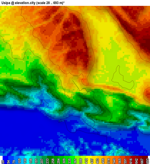
Below is the Elevation map of Usipa, which displays elevation range with different colors. Scale of the first map is from 28 to 693 m (92 to 2274 ft) with average elevation of 326.8 meters (=1072 ft) [note 1]
These maps also provides idea of topography and contour of this city, they are displayed at different zoom levels. More info about maps, scale and edge coordinates you can find below images.
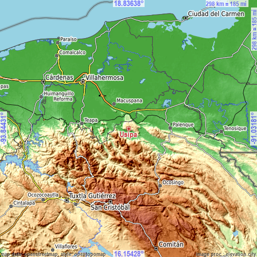
| \ | Map #1 | Topo.Map |
| Scale [m] | 28..693 m | × |
| Scale [ft] | 92..2274 ft | × |
| Average | 326.8 m = 1072 ft | × |
| Width | 9.32 km = 5.8 mi | 298.2 km = 185.3 mi |
| Height | 9.32 km = 5.8 mi | 298.2 km = 185.3 mi |
| ↑Max Latitude | 17.542186° | 18.83638° |
| Latitude at center | 17.50028° | 17.50028° |
| ↓Min Latitude | 17.458364° | 16.15428° |
| ← Min Longitude | -92.482005° | -93.84431° |
| Longitude center | -92.43806° | -92.43806° |
| →Max Longitude | -92.394115° | -91.03181° |
Nearby cities:
Cities around Usipa sort by population:
• Tila elevation 1035 m
22.2 km,  177°
177°
• Salto de Agua 14 m
12.1 km,  60°
60°
• El Limar 82 m
10.2 km,  158°
158°
• Chulum Juárez 830 m
21.3 km,  208°
208°
• Nuevo Limar 60 m
6.5 km,  140°
140°
• Buena Vista (Apasco) 27 m
17.3 km,  357°
357°
• Palomas 30 m
17.7 km,  346°
346°
• Chulum Cárdenas 1156 m
19.3 km,  228°
228°
• Misija 1250 m
26.7 km,  167°
167°
• Mariscal Subikuski 1525 m
19.6 km, 161°
• Unión Juárez 1151 m
24.7 km, 170°
• Cenobio Aguilar (La Trinidad) 95 m
16.5 km,  130°
130°
Multilingual:
 En español:
Usipa elevación 437 m.
 En France:
Usipa élévation 437 m.


Sources and notes:
- [note 1] Map square and city borders are not equal. Map elevation data is calculated only from area inside that square.
- [src 1] Elevation data from geonames database provided with same terms of usage.
- [src 2] The elevation map of Usipa is generated using elevation data from NASA's 3 arcsec (90m) resolution SRTM data.
- [src 3] Base (background) map © OpenStreetMap contributors tiles are generated by Geofabrik and OpenTopoMap.
Copyright & License:
This Usipa Elevation Map is licensed under CC BY-SA. You may reuse any part from this page, if you give a proper credit by linking to this URL:
 More info on terms of use page.