Tila elevation
Tila (Chiapas), Mexico elevation is 1035 meters and Tila elevation in feet is 3396 ft above sea level [src 1]. Tila is a seat of a second-order administrative division (feature code) with elevation that is 279 meters (915 ft) smaller than average city elevation in Mexico.
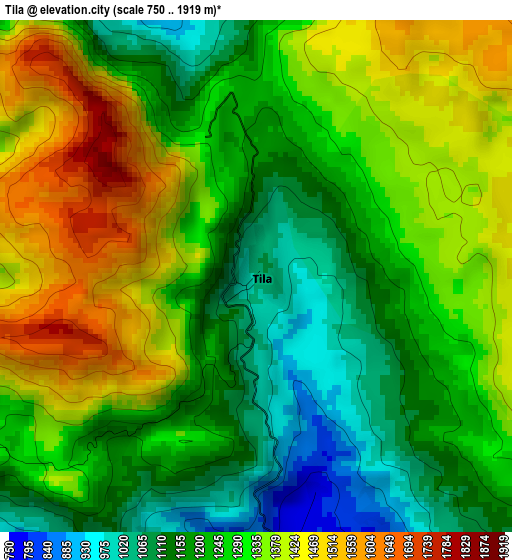
Below is the Elevation map of Tila, which displays elevation range with different colors. Scale of the first map is from 750 to 1919 m (2461 to 6296 ft) with average elevation of 1281.5 meters (=4204 ft) [note 1]
These maps also provides idea of topography and contour of this city, they are displayed at different zoom levels. More info about maps, scale and edge coordinates you can find below images.
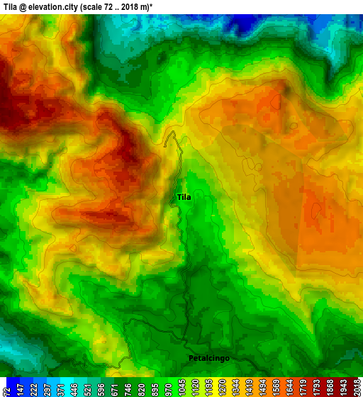
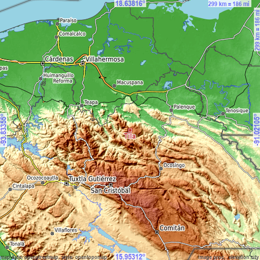
| \ | Map #1 | Map #2 | Topo.Map |
| Scale [m] | 750..1919 m | 72..2018 m | × |
| Scale [ft] | 2461..6296 ft | 236..6621 ft | × |
| Average | 1281.5 m = 4204 ft | 1120 m = 3675 ft | × |
| Width | 9.33 km = 5.8 mi | 18.66 km = 11.6 mi | 298.5 km = 185.5 mi |
| Height | 9.33 km = 5.8 mi | 18.66 km = 11.6 mi | 298.6 km = 185.5 mi |
| ↑Max Latitude | 17.342492° | 17.384435° | 18.63816° |
| Latitude at center | 17.30054° | 17.30054° | 17.30054° |
| ↓Min Latitude | 17.258578° | 17.216607° | 15.95312° |
| ← Min Longitude | -92.471245° | -92.515191° | -93.83355° |
| Longitude center | -92.4273° | -92.4273° | -92.4273° |
| →Max Longitude | -92.383355° | -92.339409° | -91.02105° |
Nearby cities:
Cities around Tila sort by population:
• Petalcingo elevation 740 m
8.3 km,  170°
170°
• Chilón 720 m
7.6 km, 171°
• Nueva Esperanza 803 m
6.6 km,  206°
206°
• Joshil 1034 m
9.1 km,  131°
131°
• Hidalgo Joshil 666 m
11.8 km, 133°
• Tocob Leglemal 822 m
9.1 km,  144°
144°
• Shoctic 667 m
10.7 km,  217°
217°
• Cantioc 881 m
4.8 km,  153°
153°
• Jolsibaquil 1049 m
7.3 km,  231°
231°
• Misija 1250 m
6.2 km, 128°
• Mariscal Subikuski 1525 m
6.1 km,  54°
54°
• Unión Juárez 1151 m
3.7 km, 126°
Multilingual:
 En español:
Tila elevación 1035 m.
 En France:
Tila élévation 1035 m.


Sources and notes:
- [note 1] Map square and city borders are not equal. Map elevation data is calculated only from area inside that square.
- [src 1] Elevation data from geonames database provided with same terms of usage.
- [src 2] The elevation map of Tila is generated using elevation data from NASA's 3 arcsec (90m) resolution SRTM data.
- [src 3] Base (background) map © OpenStreetMap contributors tiles are generated by Geofabrik and OpenTopoMap.
Copyright & License:
This Tila Elevation Map is licensed under CC BY-SA. You may reuse any part from this page, if you give a proper credit by linking to this URL:
 More info on terms of use page.