Chulum Cárdenas elevation
Chulum Cárdenas (Chiapas, Tila), Mexico elevation is 1156 meters and Chulum Cárdenas elevation in feet is 3793 ft above sea level [src 1]. Chulum Cárdenas is a populated place (feature code) with elevation that is 158 meters (518 ft) smaller than average city elevation in Mexico.
Below is the Elevation map of Chulum Cárdenas, which displays elevation range with different colors. Scale of the first map is from 146 to 2064 m (479 to 6772 ft) with average elevation of 1038.4 meters (=3407 ft) [note 1]
These maps also provides idea of topography and contour of this city, they are displayed at different zoom levels. More info about maps, scale and edge coordinates you can find below images.
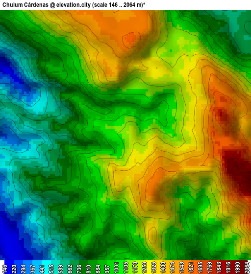
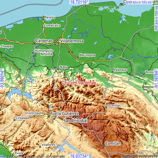
| \ | Map #1 | Topo.Map |
| Scale [m] | 146..2064 m | × |
| Scale [ft] | 479..6772 ft | × |
| Average | 1038.4 m = 3407 ft | × |
| Width | 9.33 km = 5.8 mi | 298.4 km = 185.4 mi |
| Height | 9.33 km = 5.8 mi | 298.4 km = 185.4 mi |
| ↑Max Latitude | 17.426103° | 18.72116° |
| Latitude at center | 17.38417° | 17.38417° |
| ↓Min Latitude | 17.342227° | 16.03734° |
| ← Min Longitude | -92.617835° | -93.98014° |
| Longitude center | -92.57389° | -92.57389° |
| →Max Longitude | -92.529945° | -91.16764° |
Nearby cities:
Cities around Chulum Cárdenas sort by population:
• Tila elevation 1035 m
18.1 km,  120°
120°
• Sabanilla 266 m
11.4 km,  168°
168°
• Los Naranjos 1077 m
14.2 km,  200°
200°
• Chulum Juárez 830 m
7.2 km,  143°
143°
• Moyos 603 m
7.7 km,  248°
248°
• Raya Zaragoza 80 m
12.1 km,  281°
281°
• Puxcatán 58 m
14.1 km,  301°
301°
• Buenavista 597 m
18.3 km,  164°
164°
• Majastic 813 m
12 km,  208°
208°
• Jolsibaquil 1049 m
16.9 km, 144°
• El Paraíso 537 m
15.4 km, 173°
• Libertad 239 m
15.3 km, 280°
Multilingual:
 En español:
Chulum Cárdenas elevación 1156 m.
 En France:
Chulum Cárdenas élévation 1156 m.
 Auf Deutsch:
Chulum Cárdenas höhe über dem Meeresspiegel ist 1156 m.

Sources and notes:
- [note 1] Map square and city borders are not equal. Map elevation data is calculated only from area inside that square.
- [src 1] Elevation data from geonames database provided with same terms of usage.
- [src 2] The elevation map of Chulum Cárdenas is generated using elevation data from NASA's 3 arcsec (90m) resolution SRTM data.
- [src 3] Base (background) map © OpenStreetMap contributors tiles are generated by Geofabrik and OpenTopoMap.
Copyright & License:
This Chulum Cárdenas Elevation Map is licensed under CC BY-SA. You may reuse any part from this page, if you give a proper credit by linking to this URL:
 More info on terms of use page.