El Porvenir I elevation
El Porvenir I (State of Mexico, Zinacantepec), Mexico elevation is 2696 meters and El Porvenir I elevation in feet is 8845 ft above sea level [src 1]. El Porvenir I is a populated place (feature code) with elevation that is 1382 meters (4534 ft) bigger than average city elevation in Mexico.
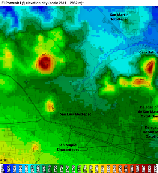
Below is the Elevation map of El Porvenir I, which displays elevation range with different colors. Scale of the first map is from 2611 to 2932 m (8566 to 9619 ft) with average elevation of 2722.2 meters (=8931 ft) [note 1]
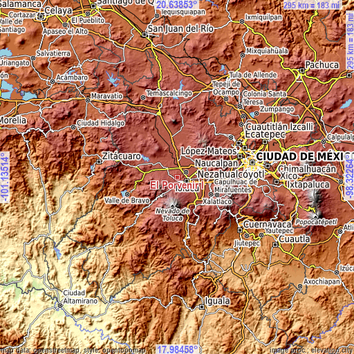
These maps also provides idea of topography and contour of this city, they are displayed at different zoom levels. More info about maps, scale and edge coordinates you can find below images.
| \ | Map #1 | Topo.Map |
| Scale [m] | 2611..2932 m | × |
| Scale [ft] | 8566..9619 ft | × |
| Average | 2722.2 m = 8931 ft | × |
| Width | 9.22 km = 5.7 mi | 295.1 km = 183.4 mi |
| Height | 9.22 km = 5.7 mi | 295.1 km = 183.4 mi |
| ↑Max Latitude | 19.358406° | 20.63853° |
| Latitude at center | 19.31694° | 19.31694° |
| ↓Min Latitude | 19.275463° | 17.98458° |
| ← Min Longitude | -99.772835° | -101.13514° |
| Longitude center | -99.72889° | -99.72889° |
| →Max Longitude | -99.684945° | -98.32264° |
Nearby cities:
Cities around El Porvenir I sort by population:
• Zinacantepec elevation 2754 m
3.7 km,  188°
188°
• San Francisco Tlalcilalcalpan 2769 m
4.8 km,  238°
238°
• Calixtlahuaca 2645 m
4.7 km,  62°
62°
• Santiaguito Tlalcilalcalli 2703 m
2.6 km,  3°
3°
• Ejido San Lorenzo Cuauhtenco 2745 m
2.8 km,  232°
232°
• La Cabecera 2632 m
4.8 km,  335°
335°
• Conjunto Urbano la Loma I 2731 m
1.1 km, 343°
• San Mateo Tlalchichilpan 2726 m
4.2 km,  313°
313°
• Tecaxic 2711 m
1.6 km,  65°
65°
• San Martín Toltepec 2685 m
4.6 km,  31°
31°
• Cerro del Murciélago 2789 m
4.7 km,  214°
214°
• San José Barbabosa 2749 m
4.7 km,  168°
168°
Multilingual:
 En español:
El Porvenir I elevación 2696 m.
 En France:
El Porvenir I élévation 2696 m.
 Auf Deutsch:
El Porvenir I höhe über dem Meeresspiegel ist 2696 m.

Sources and notes:
- [note 1] Map square and city borders are not equal. Map elevation data is calculated only from area inside that square.
- [src 1] Elevation data from geonames database provided with same terms of usage.
- [src 2] The elevation map of El Porvenir I is generated using elevation data from NASA's 3 arcsec (90m) resolution SRTM data.
- [src 3] Base (background) map © OpenStreetMap contributors tiles are generated by Geofabrik and OpenTopoMap.
Copyright & License:
This El Porvenir I Elevation Map is licensed under CC BY-SA. You may reuse any part from this page, if you give a proper credit by linking to this URL:
 More info on terms of use page.