La Cabecera elevation
La Cabecera (State of Mexico, Almoloya de Juárez), Mexico elevation is 2632 meters and La Cabecera elevation in feet is 8635 ft above sea level [src 1]. La Cabecera is a populated place (feature code) with elevation that is 1318 meters (4324 ft) bigger than average city elevation in Mexico.
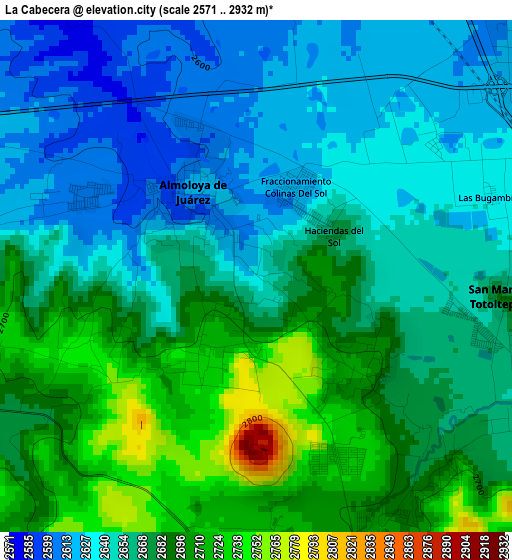
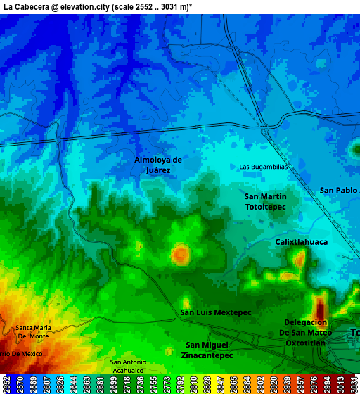
Below is the Elevation map of La Cabecera, which displays elevation range with different colors. Scale of the first map is from 2571 to 2932 m (8435 to 9619 ft) with average elevation of 2666 meters (=8747 ft) [note 1]
These maps also provides idea of topography and contour of this city, they are displayed at different zoom levels. More info about maps, scale and edge coordinates you can find below images.
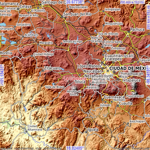
| \ | Map #1 | Map #2 | Topo.Map |
| Scale [m] | 2571..2932 m | 2552..3031 m | × |
| Scale [ft] | 8435..9619 ft | 8373..9944 ft | × |
| Average | 2666 m = 8747 ft | 2670.8 m = 8762 ft | × |
| Width | 9.22 km = 5.7 mi | 18.44 km = 11.5 mi | 295 km = 183.3 mi |
| Height | 9.22 km = 5.7 mi | 18.44 km = 11.5 mi | 295 km = 183.3 mi |
| ↑Max Latitude | 19.397566° | 19.439012° | 20.67738° |
| Latitude at center | 19.35611° | 19.35611° | 19.35611° |
| ↓Min Latitude | 19.314643° | 19.273166° | 18.02405° |
| ← Min Longitude | -99.792005° | -99.835951° | -101.15431° |
| Longitude center | -99.74806° | -99.74806° | -99.74806° |
| →Max Longitude | -99.704115° | -99.660169° | -98.34181° |
Nearby cities:
Cities around La Cabecera sort by population:
• Santiaguito Tlalcilalcalli elevation 2703 m
2.8 km,  128°
128°
• Fraccionamiento Colinas del Sol 2622 m
2 km,  24°
24°
• Conjunto Urbano la Loma I 2731 m
3.7 km,  152°
152°
• San Mateo Tlalchichilpan 2726 m
1.8 km,  214°
214°
• Villa de Almoloya de Juárez 2615 m
1.8 km,  323°
323°
• San Martín Toltepec 2685 m
4.5 km,  95°
95°
• Conjunto Habitacional Ecológico SUTEYM 2606 m
3.5 km,  293°
293°
• Santa Juana Primera Sección 2603 m
3.8 km,  353°
353°
• Loma de San Miguel 2719 m
4.8 km,  250°
250°
• Sebastián Lerdo de Tejada 2623 m
4.4 km,  32°
32°
• El Porvenir I 2696 m
4.8 km,  155°
155°
• El Tepetatal 2708 m
2.7 km,  244°
244°
Multilingual:
 En español:
La Cabecera elevación 2632 m.
 En France:
La Cabecera élévation 2632 m.
 Auf Deutsch:
La Cabecera höhe über dem Meeresspiegel ist 2632 m.

Sources and notes:
- [note 1] Map square and city borders are not equal. Map elevation data is calculated only from area inside that square.
- [src 1] Elevation data from geonames database provided with same terms of usage.
- [src 2] The elevation map of La Cabecera is generated using elevation data from NASA's 3 arcsec (90m) resolution SRTM data.
- [src 3] Base (background) map © OpenStreetMap contributors tiles are generated by Geofabrik and OpenTopoMap.
Copyright & License:
This La Cabecera Elevation Map is licensed under CC BY-SA. You may reuse any part from this page, if you give a proper credit by linking to this URL:
 More info on terms of use page.