Villa Santiago elevation
Villa Santiago (Morelos, Cuernavaca), Mexico elevation is 1788 meters and Villa Santiago elevation in feet is 5866 ft above sea level [src 1]. Villa Santiago is a populated place (feature code) with elevation that is 474 meters (1555 ft) bigger than average city elevation in Mexico.
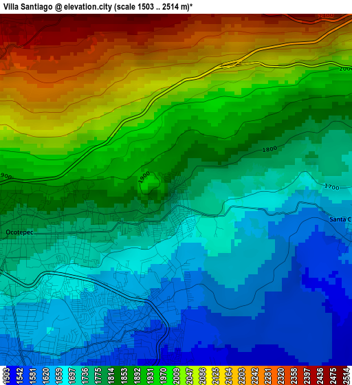
Below is the Elevation map of Villa Santiago, which displays elevation range with different colors. Scale of the first map is from 1503 to 2514 m (4931 to 8248 ft) with average elevation of 1855.4 meters (=6087 ft) [note 1]
These maps also provides idea of topography and contour of this city, they are displayed at different zoom levels. More info about maps, scale and edge coordinates you can find below images.
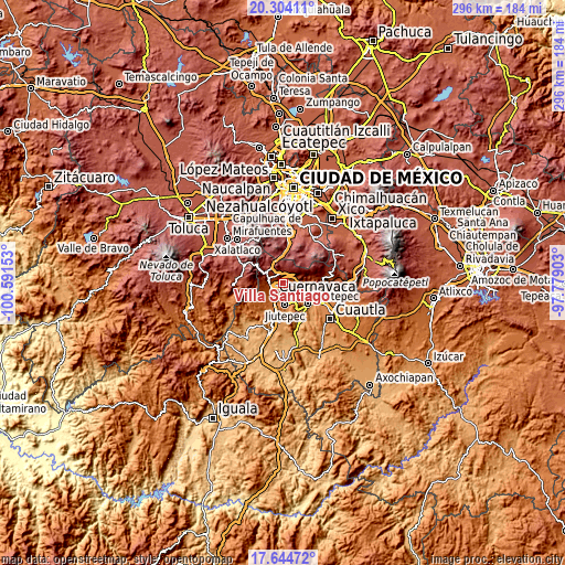
| \ | Map #1 | Topo.Map |
| Scale [m] | 1503..2514 m | × |
| Scale [ft] | 4931..8248 ft | × |
| Average | 1855.4 m = 6087 ft | × |
| Width | 9.24 km = 5.7 mi | 295.7 km = 183.7 mi |
| Height | 9.24 km = 5.7 mi | 295.7 km = 183.7 mi |
| ↑Max Latitude | 19.021271° | 20.30411° |
| Latitude at center | 18.97972° | 18.97972° |
| ↓Min Latitude | 18.938159° | 17.64472° |
| ← Min Longitude | -99.229225° | -100.59153° |
| Longitude center | -99.18528° | -99.18528° |
| →Max Longitude | -99.141335° | -97.77903° |
Nearby cities:
Cities around Villa Santiago sort by population:
• Cuernavaca elevation 1540 m
7.6 km,  218°
218°
• Tepoztlán 1722 m
8.9 km,  85°
85°
• Fraccionamiento Lomas de Ahuatlán 1745 m
8.1 km,  249°
249°
• Huitzilac 2560 m
10.3 km,  302°
302°
• Santa Catarina 1621 m
4.9 km,  103°
103°
• Loma Bonita 1491 m
5.5 km,  169°
169°
• Coajomulco 2642 m
6.3 km,  341°
341°
• Fraccionamiento Universo 1638 m
2 km,  183°
183°
• Tetecolala 1443 m
6.8 km,  159°
159°
• San Andrés de la Cal 1499 m
7.9 km,  108°
108°
• Colonia los Cerritos 1615 m
3 km,  194°
194°
• Lomas de Ahuatepec 1739 m
1 km,  206°
206°
Multilingual:
 En español:
Villa Santiago elevación 1788 m.
 En France:
Villa Santiago élévation 1788 m.
 Auf Deutsch:
Villa Santiago höhe über dem Meeresspiegel ist 1788 m.

Sources and notes:
- [note 1] Map square and city borders are not equal. Map elevation data is calculated only from area inside that square.
- [src 1] Elevation data from geonames database provided with same terms of usage.
- [src 2] The elevation map of Villa Santiago is generated using elevation data from NASA's 3 arcsec (90m) resolution SRTM data.
- [src 3] Base (background) map © OpenStreetMap contributors tiles are generated by Geofabrik and OpenTopoMap.
Copyright & License:
This Villa Santiago Elevation Map is licensed under CC BY-SA. You may reuse any part from this page, if you give a proper credit by linking to this URL:
 More info on terms of use page.