Tepoztlán elevation
Tepoztlán (Morelos), Mexico elevation is 1722 meters and Tepoztlán elevation in feet is 5650 ft above sea level [src 1]. Tepoztlán is a seat of a second-order administrative division (feature code) with elevation that is 408 meters (1339 ft) bigger than average city elevation in Mexico.
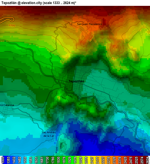
Below is the Elevation map of Tepoztlán, which displays elevation range with different colors. Scale of the first map is from 1333 to 2624 m (4373 to 8609 ft) with average elevation of 1839.4 meters (=6035 ft) [note 1]
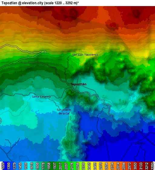
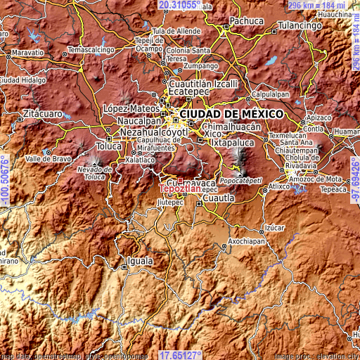
These maps also provides idea of topography and contour of this city, they are displayed at different zoom levels. More info about maps, scale and edge coordinates you can find below images.
| \ | Map #1 | Map #2 | Topo.Map |
| Scale [m] | 1333..2624 m | 1220..3292 m | × |
| Scale [ft] | 4373..8609 ft | 4003..10801 ft | × |
| Average | 1839.4 m = 6035 ft | 2006.2 m = 6582 ft | × |
| Width | 9.24 km = 5.7 mi | 18.48 km = 11.5 mi | 295.7 km = 183.7 mi |
| Height | 9.24 km = 5.7 mi | 18.48 km = 11.5 mi | 295.7 km = 183.7 mi |
| ↑Max Latitude | 19.027769° | 19.069308° | 20.31055° |
| Latitude at center | 18.98622° | 18.98622° | 18.98622° |
| ↓Min Latitude | 18.94466° | 18.90309° | 17.65127° |
| ← Min Longitude | -99.144455° | -99.188401° | -100.50676° |
| Longitude center | -99.10051° | -99.10051° | -99.10051° |
| →Max Longitude | -99.056565° | -99.012619° | -97.69426° |
Nearby cities:
Cities around Tepoztlán sort by population:
• Santa Catarina elevation 1621 m
4.6 km,  246°
246°
• Villa Santiago 1788 m
8.9 km,  265°
265°
• Loma Bonita 1491 m
10 km,  232°
232°
• Fraccionamiento Universo 1638 m
9.4 km, 253°
• Santo Domingo Ocotitlán 2076 m
5.2 km,  52°
52°
• Lázaro Cárdenas (El Empalme) 1285 m
9.9 km,  127°
127°
• Tetecolala 1443 m
9.6 km,  222°
222°
• San Andrés de la Cal 1499 m
3.6 km,  204°
204°
• Colonia Obrera 1290 m
8.9 km, 133°
• Colonia Ángel Bocanegra (Adolfo López Mateos) 1266 m
10 km, 131°
• Lomas de Ahuatepec 1739 m
9.5 km,  260°
260°
• Amatlán de Quetzalcoatl 1617 m
6.7 km,  100°
100°
Multilingual:
 En español:
Tepoztlán elevación 1722 m.
 En France:
Tepoztlán élévation 1722 m.
 Auf Deutsch:
Tepoztlán höhe über dem Meeresspiegel ist 1722 m.

Sources and notes:
- [note 1] Map square and city borders are not equal. Map elevation data is calculated only from area inside that square.
- [src 1] Elevation data from geonames database provided with same terms of usage.
- [src 2] The elevation map of Tepoztlán is generated using elevation data from NASA's 3 arcsec (90m) resolution SRTM data.
- [src 3] Base (background) map © OpenStreetMap contributors tiles are generated by Geofabrik and OpenTopoMap.
Copyright & License:
This Tepoztlán Elevation Map is licensed under CC BY-SA. You may reuse any part from this page, if you give a proper credit by linking to this URL:
 More info on terms of use page.