Tetecolala elevation
Tetecolala (Morelos, Tepoztlán), Mexico elevation is 1443 meters and Tetecolala elevation in feet is 4734 ft above sea level [src 1]. Tetecolala is a populated place (feature code) with elevation that is 129 meters (423 ft) bigger than average city elevation in Mexico.
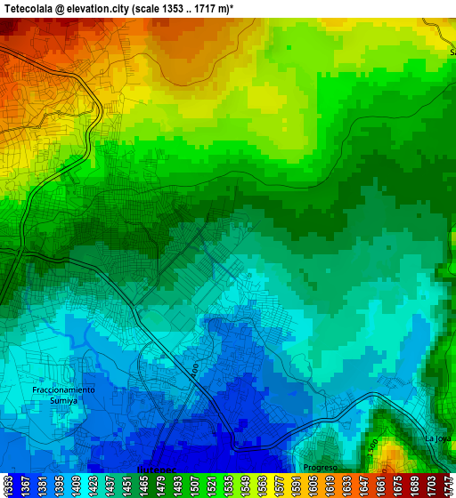
Below is the Elevation map of Tetecolala, which displays elevation range with different colors. Scale of the first map is from 1353 to 1717 m (4439 to 5633 ft) with average elevation of 1477.8 meters (=4848 ft) [note 1]
These maps also provides idea of topography and contour of this city, they are displayed at different zoom levels. More info about maps, scale and edge coordinates you can find below images.
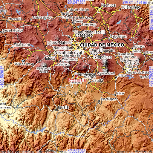
| \ | Map #1 | Topo.Map |
| Scale [m] | 1353..1717 m | × |
| Scale [ft] | 4439..5633 ft | × |
| Average | 1477.8 m = 4848 ft | × |
| Width | 9.24 km = 5.7 mi | 295.8 km = 183.8 mi |
| Height | 9.24 km = 5.7 mi | 295.8 km = 183.8 mi |
| ↑Max Latitude | 18.964065° | 20.24736° |
| Latitude at center | 18.9225° | 18.9225° |
| ↓Min Latitude | 18.880924° | 17.58706° |
| ← Min Longitude | -99.206725° | -100.56903° |
| Longitude center | -99.16278° | -99.16278° |
| →Max Longitude | -99.118835° | -97.75653° |
Nearby cities:
Cities around Tetecolala sort by population:
• Jiutepec elevation 1361 m
4.8 km,  199°
199°
• Progreso 1363 m
4.8 km,  167°
167°
• La Joya 1477 m
5.5 km,  130°
130°
• Independencia 1446 m
6.6 km,  139°
139°
• Santa Catarina 1621 m
5.8 km,  24°
24°
• Unidad Habitacional Rinconada Acolapa 1405 m
4.3 km, 130°
• Loma Bonita 1491 m
1.7 km,  306°
306°
• Cliserio Alanís (San Gaspar) 1313 m
6.8 km,  177°
177°
• Fraccionamiento Universo 1638 m
5 km,  330°
330°
• San Andrés de la Cal 1499 m
6.4 km,  53°
53°
• Colonia los Cerritos 1615 m
4.7 km,  318°
318°
• Lomas de Ahuatepec 1739 m
6.1 km, 332°
Multilingual:
 En español:
Tetecolala elevación 1443 m.
 En France:
Tetecolala élévation 1443 m.
 Auf Deutsch:
Tetecolala höhe über dem Meeresspiegel ist 1443 m.

Sources and notes:
- [note 1] Map square and city borders are not equal. Map elevation data is calculated only from area inside that square.
- [src 1] Elevation data from geonames database provided with same terms of usage.
- [src 2] The elevation map of Tetecolala is generated using elevation data from NASA's 3 arcsec (90m) resolution SRTM data.
- [src 3] Base (background) map © OpenStreetMap contributors tiles are generated by Geofabrik and OpenTopoMap.
Copyright & License:
This Tetecolala Elevation Map is licensed under CC BY-SA. You may reuse any part from this page, if you give a proper credit by linking to this URL:
 More info on terms of use page.