Independencia elevation
Independencia (Morelos, Jiutepec), Mexico elevation is 1446 meters and Independencia elevation in feet is 4744 ft above sea level [src 1]. Independencia is a populated place (feature code) with elevation that is 132 meters (433 ft) bigger than average city elevation in Mexico.
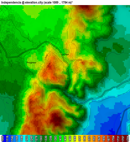
Below is the Elevation map of Independencia, which displays elevation range with different colors. Scale of the first map is from 1089 to 1784 m (3573 to 5853 ft) with average elevation of 1388.6 meters (=4556 ft) [note 1]
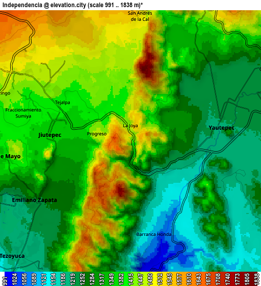
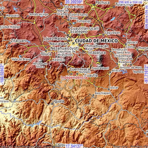
These maps also provides idea of topography and contour of this city, they are displayed at different zoom levels. More info about maps, scale and edge coordinates you can find below images.
| \ | Map #1 | Map #2 | Topo.Map |
| Scale [m] | 1089..1784 m | 991..1838 m | × |
| Scale [ft] | 3573..5853 ft | 3251..6030 ft | × |
| Average | 1388.6 m = 4556 ft | 1347.7 m = 4422 ft | × |
| Width | 9.25 km = 5.7 mi | 18.49 km = 11.5 mi | 295.9 km = 183.9 mi |
| Height | 9.25 km = 5.7 mi | 18.49 km = 11.5 mi | 295.9 km = 183.9 mi |
| ↑Max Latitude | 18.918737° | 18.960303° | 20.20239° |
| Latitude at center | 18.87716° | 18.87716° | 18.87716° |
| ↓Min Latitude | 18.835573° | 18.793976° | 17.54137° |
| ← Min Longitude | -99.166315° | -99.210261° | -100.52862° |
| Longitude center | -99.12237° | -99.12237° | -99.12237° |
| →Max Longitude | -99.078425° | -99.034479° | -97.71612° |
Nearby cities:
Cities around Independencia sort by population:
• Jiutepec elevation 1361 m
5.8 km,  274°
274°
• Emiliano Zapata 1272 m
7.7 km,  238°
238°
• Yautepec 1225 m
5.8 km,  84°
84°
• Tres de Mayo 1379 m
9.1 km,  263°
263°
• Progreso 1363 m
3.2 km,  275°
275°
• La Joya 1477 m
1.5 km,  355°
355°
• Calera Chica 1316 m
6.6 km,  251°
251°
• Unidad Habitacional Rinconada Acolapa 1405 m
2.4 km,  336°
336°
• Loma Bonita 1491 m
8.2 km,  317°
317°
• Cliserio Alanís (San Gaspar) 1313 m
4.3 km, 245°
• Tetecolala 1443 m
6.6 km, 319°
• San Andrés de la Cal 1499 m
8.9 km,  5°
5°
Multilingual:
 En español:
Independencia elevación 1446 m.
 En France:
Independencia élévation 1446 m.
 Auf Deutsch:
Independencia höhe über dem Meeresspiegel ist 1446 m.

Sources and notes:
- [note 1] Map square and city borders are not equal. Map elevation data is calculated only from area inside that square.
- [src 1] Elevation data from geonames database provided with same terms of usage.
- [src 2] The elevation map of Independencia is generated using elevation data from NASA's 3 arcsec (90m) resolution SRTM data.
- [src 3] Base (background) map © OpenStreetMap contributors tiles are generated by Geofabrik and OpenTopoMap.
Copyright & License:
This Independencia Elevation Map is licensed under CC BY-SA. You may reuse any part from this page, if you give a proper credit by linking to this URL:
 More info on terms of use page.