Yautepec elevation
Yautepec (Morelos), Mexico elevation is 1225 meters and Yautepec elevation in feet is 4019 ft above sea level [src 1]. Yautepec is a populated place (feature code) with elevation that is 89 meters (292 ft) smaller than average city elevation in Mexico.
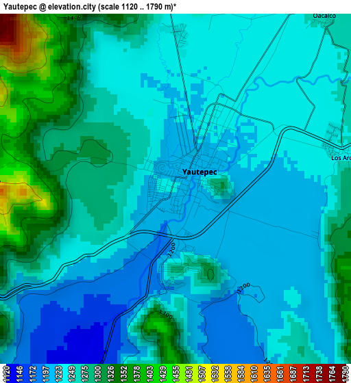
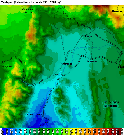
Below is the Elevation map of Yautepec, which displays elevation range with different colors. Scale of the first map is from 1120 to 1790 m (3675 to 5873 ft) with average elevation of 1257.3 meters (=4125 ft) [note 1]
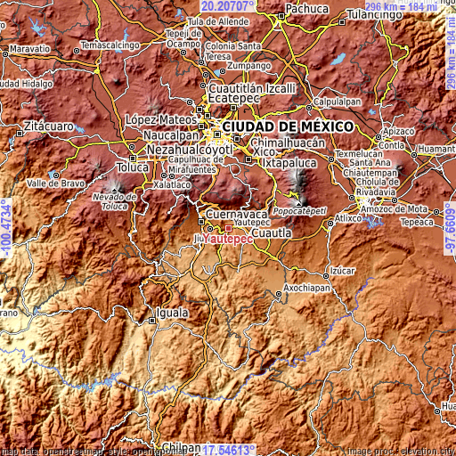
These maps also provides idea of topography and contour of this city, they are displayed at different zoom levels. More info about maps, scale and edge coordinates you can find below images.
| \ | Map #1 | Map #2 | Topo.Map |
| Scale [m] | 1120..1790 m | 995..2068 m | × |
| Scale [ft] | 3675..5873 ft | 3264..6785 ft | × |
| Average | 1257.3 m = 4125 ft | 1343.3 m = 4407 ft | × |
| Width | 9.25 km = 5.7 mi | 18.49 km = 11.5 mi | 295.9 km = 183.9 mi |
| Height | 9.25 km = 5.7 mi | 18.49 km = 11.5 mi | 295.9 km = 183.9 mi |
| ↑Max Latitude | 18.923455° | 18.96502° | 20.20707° |
| Latitude at center | 18.88188° | 18.88188° | 18.88188° |
| ↓Min Latitude | 18.840294° | 18.798698° | 17.54613° |
| ← Min Longitude | -99.111095° | -99.155041° | -100.4734° |
| Longitude center | -99.06715° | -99.06715° | -99.06715° |
| →Max Longitude | -99.023205° | -98.979259° | -97.6609° |
Nearby cities:
Cities around Yautepec sort by population:
• Progreso elevation 1363 m
9 km,  268°
268°
• La Joya 1477 m
6 km,  279°
279°
• Cocoyoc 1327 m
9 km,  88°
88°
• Independencia 1446 m
5.8 km,  264°
264°
• Los Arcos 1256 m
4.6 km,  82°
82°
• Unidad Habitacional Rinconada Acolapa 1405 m
7 km, 284°
• Oacalco 1256 m
6.1 km,  40°
40°
• Lázaro Cárdenas (El Empalme) 1285 m
7.1 km, 38°
• Colonia Obrera 1290 m
6.3 km,  28°
28°
• Itzamatitlán 1252 m
5.6 km,  56°
56°
• Colonia Ángel Bocanegra (Adolfo López Mateos) 1266 m
6.3 km, 38°
• Ignacio Bastida (Santa Catarina Tlayca) 1302 m
8.5 km, 40°
Multilingual:
 En español:
Yautepec de Zaragoza elevación 1225 m.
 En France:
Yautepec élévation 1225 m.
 Auf Deutsch:
Yautepec höhe über dem Meeresspiegel ist 1225 m.

Sources and notes:
- [note 1] Map square and city borders are not equal. Map elevation data is calculated only from area inside that square.
- [src 1] Elevation data from geonames database provided with same terms of usage.
- [src 2] The elevation map of Yautepec is generated using elevation data from NASA's 3 arcsec (90m) resolution SRTM data.
- [src 3] Base (background) map © OpenStreetMap contributors tiles are generated by Geofabrik and OpenTopoMap.
Copyright & License:
This Yautepec Elevation Map is licensed under CC BY-SA. You may reuse any part from this page, if you give a proper credit by linking to this URL:
 More info on terms of use page.