La Pradera elevation
La Pradera (Querétaro, El Marqués), Mexico elevation is 2037 meters and La Pradera elevation in feet is 6683 ft above sea level [src 1]. La Pradera is a populated place (feature code) with elevation that is 723 meters (2372 ft) bigger than average city elevation in Mexico.
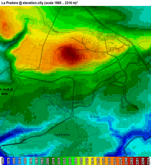
Below is the Elevation map of La Pradera, which displays elevation range with different colors. Scale of the first map is from 1860 to 2316 m (6102 to 7598 ft) with average elevation of 2033.1 meters (=6670 ft) [note 1]
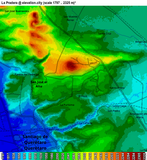
These maps also provides idea of topography and contour of this city, they are displayed at different zoom levels. More info about maps, scale and edge coordinates you can find below images.
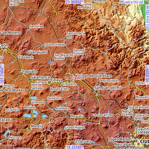
| \ | Map #1 | Map #2 | Topo.Map |
| Scale [m] | 1860..2316 m | 1797..2325 m | × |
| Scale [ft] | 6102..7598 ft | 5896..7628 ft | × |
| Average | 2033.1 m = 6670 ft | 1969.5 m = 6462 ft | × |
| Width | 9.14 km = 5.7 mi | 18.29 km = 11.4 mi | 292.6 km = 181.8 mi |
| Height | 9.14 km = 5.7 mi | 18.29 km = 11.4 mi | 292.6 km = 181.8 mi |
| ↑Max Latitude | 20.700004° | 20.741107° | 21.96892° |
| Latitude at center | 20.65889° | 20.65889° | 20.65889° |
| ↓Min Latitude | 20.617765° | 20.576629° | 19.33747° |
| ← Min Longitude | -100.386165° | -100.430111° | -101.74847° |
| Longitude center | -100.34222° | -100.34222° | -100.34222° |
| →Max Longitude | -100.298275° | -100.254329° | -98.93597° |
Nearby cities:
Cities around La Pradera sort by population:
• Santiago de Querétaro elevation 1826 m
9.2 km,  211°
211°
• San José el Alto 2036 m
4.2 km,  261°
261°
• La Cañada 1857 m
5.7 km,  170°
170°
• Saldarriaga 1895 m
6.2 km,  124°
124°
• El Salitre 1846 m
8.4 km,  275°
275°
• Santa Cruz 1950 m
7.1 km,  33°
33°
• Paseos del Pedregal 1921 m
5.8 km, 275°
• Hacienda la Cruz [Fraccionamiento] 1891 m
8.7 km,  108°
108°
• San Vicente Ferrer 1951 m
7.6 km,  357°
357°
• Ninguno [CERESO] 2180 m
2.5 km,  311°
311°
• Sergio Villaseñor 1969 m
8.3 km, 259°
• El Pozo 1939 m
2.6 km,  158°
158°
Multilingual:
 En español:
La Pradera elevación 2037 m.
 En France:
La Pradera élévation 2037 m.
 Auf Deutsch:
La Pradera höhe über dem Meeresspiegel ist 2037 m.

Sources and notes:
- [note 1] Map square and city borders are not equal. Map elevation data is calculated only from area inside that square.
- [src 1] Elevation data from geonames database provided with same terms of usage.
- [src 2] The elevation map of La Pradera is generated using elevation data from NASA's 3 arcsec (90m) resolution SRTM data.
- [src 3] Base (background) map © OpenStreetMap contributors tiles are generated by Geofabrik and OpenTopoMap.
Copyright & License:
This La Pradera Elevation Map is licensed under CC BY-SA. You may reuse any part from this page, if you give a proper credit by linking to this URL:
 More info on terms of use page.