La Cañada elevation
La Cañada (Querétaro, El Marqués), Mexico elevation is 1857 meters and La Cañada elevation in feet is 6093 ft above sea level [src 1]. La Cañada is a seat of a second-order administrative division (feature code) with elevation that is 543 meters (1781 ft) bigger than average city elevation in Mexico.
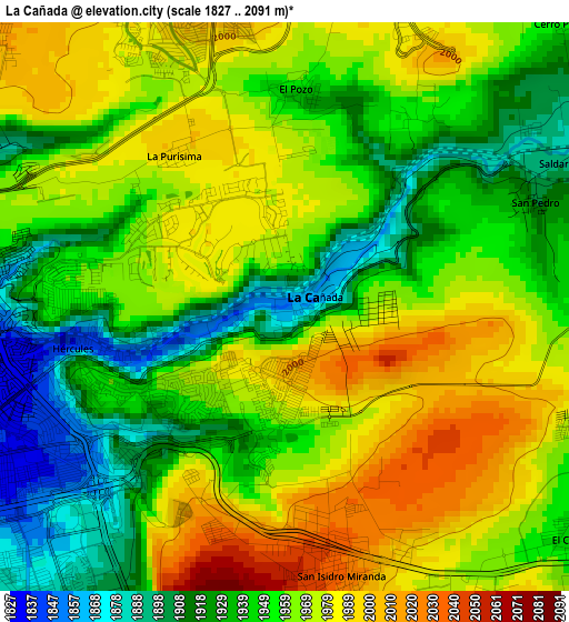
Below is the Elevation map of La Cañada, which displays elevation range with different colors. Scale of the first map is from 1827 to 2091 m (5994 to 6860 ft) with average elevation of 1957 meters (=6421 ft) [note 1]
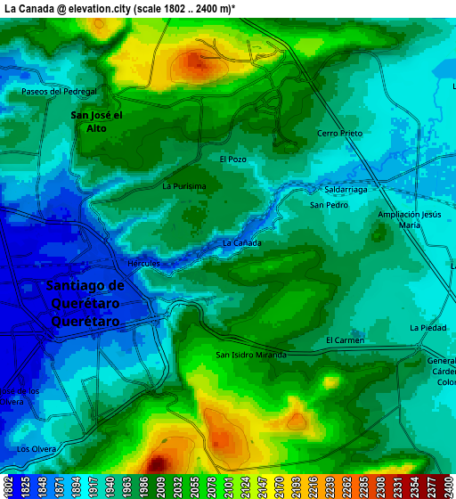
These maps also provides idea of topography and contour of this city, they are displayed at different zoom levels. More info about maps, scale and edge coordinates you can find below images.
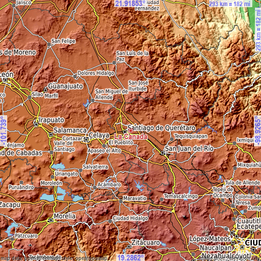
| \ | Map #1 | Map #2 | Topo.Map |
| Scale [m] | 1827..2091 m | 1802..2400 m | × |
| Scale [ft] | 5994..6860 ft | 5912..7874 ft | × |
| Average | 1957 m = 6421 ft | 1970.3 m = 6464 ft | × |
| Width | 9.15 km = 5.7 mi | 18.29 km = 11.4 mi | 292.7 km = 181.9 mi |
| Height | 9.15 km = 5.7 mi | 18.29 km = 11.4 mi | 292.7 km = 181.9 mi |
| ↑Max Latitude | 20.649178° | 20.690294° | 21.91853° |
| Latitude at center | 20.60805° | 20.60805° | 20.60805° |
| ↓Min Latitude | 20.566911° | 20.525761° | 19.2862° |
| ← Min Longitude | -100.376695° | -100.420641° | -101.739° |
| Longitude center | -100.33275° | -100.33275° | -100.33275° |
| →Max Longitude | -100.288805° | -100.244859° | -98.9265° |
Nearby cities:
Cities around La Cañada sort by population:
• Santiago de Querétaro elevation 1826 m
6.2 km,  248°
248°
• San José el Alto 2036 m
7.2 km,  314°
314°
• La Pradera 2037 m
5.7 km,  350°
350°
• Saldarriaga 1895 m
4.7 km,  61°
61°
• La Piedad 1922 m
8.6 km,  112°
112°
• San Isidro Miranda 2031 m
4.3 km,  168°
168°
• Jesús María 1900 m
8.1 km,  78°
78°
• Paseos del Pedregal 1921 m
9.2 km, 312°
• Hacienda la Cruz [Fraccionamiento] 1891 m
7.8 km,  68°
68°
• Ninguno [CERESO] 2180 m
7.8 km,  338°
338°
• El Pozo 1939 m
3.3 km,  359°
359°
• El Carmen 1946 m
6 km,  128°
128°
Multilingual:
 En español:
La Cañada elevación 1857 m.
 En France:
La Cañada élévation 1857 m.
 Auf Deutsch:
La Cañada höhe über dem Meeresspiegel ist 1857 m.

Sources and notes:
- [note 1] Map square and city borders are not equal. Map elevation data is calculated only from area inside that square.
- [src 1] Elevation data from geonames database provided with same terms of usage.
- [src 2] The elevation map of La Cañada is generated using elevation data from NASA's 3 arcsec (90m) resolution SRTM data.
- [src 3] Base (background) map © OpenStreetMap contributors tiles are generated by Geofabrik and OpenTopoMap.
Copyright & License:
This La Cañada Elevation Map is licensed under CC BY-SA. You may reuse any part from this page, if you give a proper credit by linking to this URL:
 More info on terms of use page.