Chanal elevation
Chanal (Chiapas), Mexico elevation is 2084 meters and Chanal elevation in feet is 6837 ft above sea level [src 1]. Chanal is a populated place (feature code) with elevation that is 770 meters (2526 ft) bigger than average city elevation in Mexico.
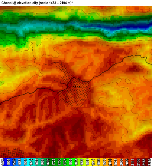
Below is the Elevation map of Chanal, which displays elevation range with different colors. Scale of the first map is from 1473 to 2194 m (4833 to 7198 ft) with average elevation of 1986.7 meters (=6518 ft) [note 1]
These maps also provides idea of topography and contour of this city, they are displayed at different zoom levels. More info about maps, scale and edge coordinates you can find below images.

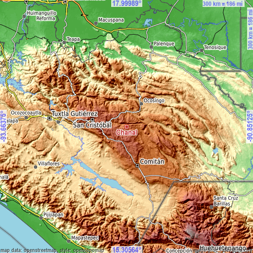
| \ | Map #1 | Map #2 | Topo.Map |
| Scale [m] | 1473..2194 m | 1369..2433 m | × |
| Scale [ft] | 4833..7198 ft | 4491..7982 ft | × |
| Average | 1986.7 m = 6518 ft | 2053.4 m = 6737 ft | × |
| Width | 9.36 km = 5.8 mi | 18.72 km = 11.6 mi | 299.6 km = 186.2 mi |
| Height | 9.36 km = 5.8 mi | 18.72 km = 11.6 mi | 299.6 km = 186.2 mi |
| ↑Max Latitude | 16.699597° | 16.741684° | 17.99989° |
| Latitude at center | 16.6575° | 16.6575° | 16.6575° |
| ↓Min Latitude | 16.615394° | 16.573279° | 15.30564° |
| ← Min Longitude | -92.301445° | -92.345391° | -93.66375° |
| Longitude center | -92.2575° | -92.2575° | -92.2575° |
| →Max Longitude | -92.213555° | -92.169609° | -90.85125° |
Nearby cities:
Cities around Chanal sort by population:
• Oxchuc elevation 1967 m
17 km,  327°
327°
• Chanal 1963 m
16.5 km,  293°
293°
• Abasolo 1283 m
18.7 km,  13°
13°
• Veinte de Noviembre 1565 m
19.2 km,  102°
102°
• La Floresta 2177 m
17.5 km,  199°
199°
• Huixtán 2011 m
21.7 km, 285°
• El Tzay 1523 m
23.6 km,  345°
345°
• Los Pozos 2247 m
16 km,  266°
266°
• Tzopilja 2130 m
10.7 km, 328°
• El Vergel 1581 m
20.7 km,  114°
114°
• Carmen Yalchuch 2088 m
11.3 km,  262°
262°
• San José Yashitinín 2358 m
20 km, 269°
Multilingual:
 En español:
Chanal elevación 2084 m.
 En France:
Chanal élévation 2084 m.


Sources and notes:
- [note 1] Map square and city borders are not equal. Map elevation data is calculated only from area inside that square.
- [src 1] Elevation data from geonames database provided with same terms of usage.
- [src 2] The elevation map of Chanal is generated using elevation data from NASA's 3 arcsec (90m) resolution SRTM data.
- [src 3] Base (background) map © OpenStreetMap contributors tiles are generated by Geofabrik and OpenTopoMap.
Copyright & License:
This Chanal Elevation Map is licensed under CC BY-SA. You may reuse any part from this page, if you give a proper credit by linking to this URL:
 More info on terms of use page.