Chanal elevation
Chanal (Chiapas, Huixtán), Mexico elevation is 1963 meters and Chanal elevation in feet is 6440 ft above sea level [src 1]. Chanal is a populated place (feature code) with elevation that is 649 meters (2129 ft) bigger than average city elevation in Mexico.
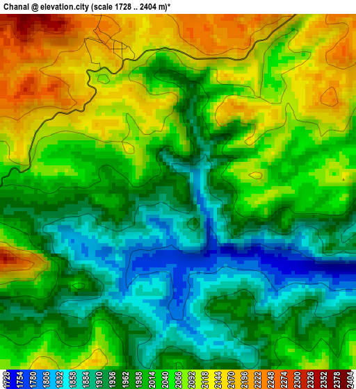
Below is the Elevation map of Chanal, which displays elevation range with different colors. Scale of the first map is from 1728 to 2404 m (5669 to 7887 ft) with average elevation of 2013.9 meters (=6607 ft) [note 1]
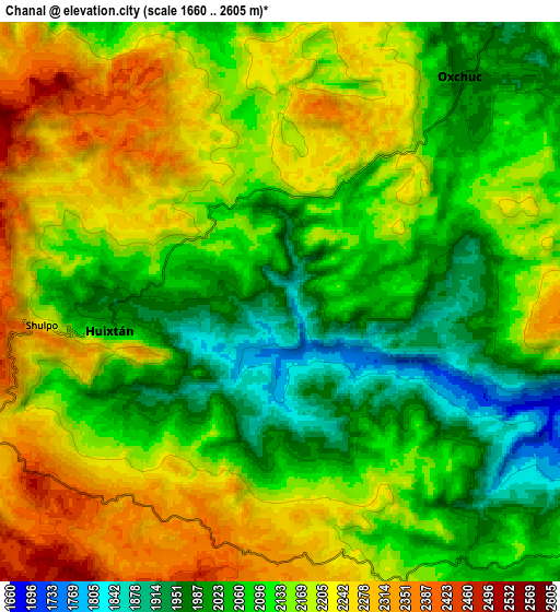
These maps also provides idea of topography and contour of this city, they are displayed at different zoom levels. More info about maps, scale and edge coordinates you can find below images.
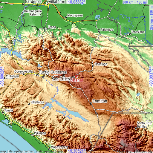
| \ | Map #1 | Map #2 | Topo.Map |
| Scale [m] | 1728..2404 m | 1660..2605 m | × |
| Scale [ft] | 5669..7887 ft | 5446..8547 ft | × |
| Average | 2013.9 m = 6607 ft | 2130.9 m = 6991 ft | × |
| Width | 9.36 km = 5.8 mi | 18.72 km = 11.6 mi | 299.5 km = 186.1 mi |
| Height | 9.36 km = 5.8 mi | 18.72 km = 11.6 mi | 299.5 km = 186.1 mi |
| ↑Max Latitude | 16.758753° | 16.800828° | 18.05862° |
| Latitude at center | 16.71667° | 16.71667° | 16.71667° |
| ↓Min Latitude | 16.674577° | 16.632475° | 15.36521° |
| ← Min Longitude | -92.443945° | -92.487891° | -93.80625° |
| Longitude center | -92.4° | -92.4° | -92.4° |
| →Max Longitude | -92.356055° | -92.312109° | -90.99375° |
Nearby cities:
Cities around Chanal sort by population:
• Oxchuc elevation 1967 m
9.7 km,  37°
37°
• Yoshib 1607 m
15.1 km,  341°
341°
• Tzajalchén 1550 m
15.3 km, 335°
• La Candelaria 2408 m
13.3 km,  282°
282°
• Yashanal 1706 m
13.6 km, 336°
• Huixtán 2011 m
5.7 km,  263°
263°
• Matzam 2384 m
11.5 km,  314°
314°
• Los Pozos 2247 m
7.7 km,  185°
185°
• Tzopilja 2130 m
10 km,  75°
75°
• Lázaro Cárdenas (Chilil) 2298 m
10.5 km,  244°
244°
• Carmen Yalchuch 2088 m
8.9 km,  153°
153°
• San José Yashitinín 2358 m
8.4 km,  214°
214°
Multilingual:
 En español:
Chanal elevación 1963 m.
 En France:
Chanal élévation 1963 m.


Sources and notes:
- [note 1] Map square and city borders are not equal. Map elevation data is calculated only from area inside that square.
- [src 1] Elevation data from geonames database provided with same terms of usage.
- [src 2] The elevation map of Chanal is generated using elevation data from NASA's 3 arcsec (90m) resolution SRTM data.
- [src 3] Base (background) map © OpenStreetMap contributors tiles are generated by Geofabrik and OpenTopoMap.
Copyright & License:
This Chanal Elevation Map is licensed under CC BY-SA. You may reuse any part from this page, if you give a proper credit by linking to this URL:
 More info on terms of use page.