Coyuquilla Norte elevation
Coyuquilla Norte (Guerrero, Petatlán), Mexico elevation is 50 meters and Coyuquilla Norte elevation in feet is 164 ft above sea level [src 1]. Coyuquilla Norte is a populated place (feature code) with elevation that is 1264 meters (4147 ft) smaller than average city elevation in Mexico.
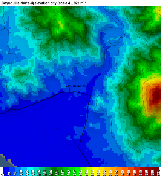
Below is the Elevation map of Coyuquilla Norte, which displays elevation range with different colors. Scale of the first map is from 4 to 921 m (13 to 3022 ft) with average elevation of 160.7 meters (=527 ft) [note 1]
These maps also provides idea of topography and contour of this city, they are displayed at different zoom levels. More info about maps, scale and edge coordinates you can find below images.
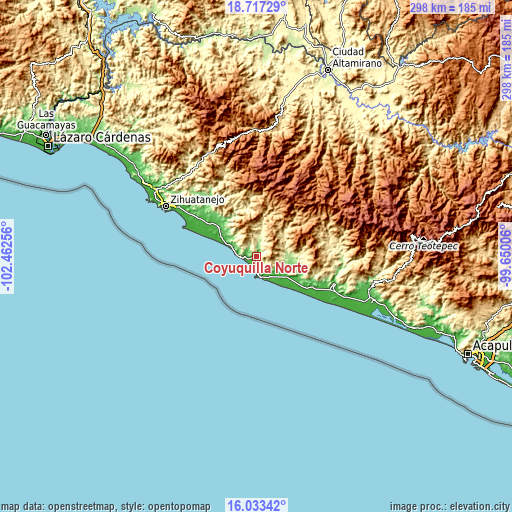
| \ | Map #1 | Topo.Map |
| Scale [m] | 4..921 m | × |
| Scale [ft] | 13..3022 ft | × |
| Average | 160.7 m = 527 ft | × |
| Width | 9.33 km = 5.8 mi | 298.4 km = 185.4 mi |
| Height | 9.33 km = 5.8 mi | 298.4 km = 185.4 mi |
| ↑Max Latitude | 17.422204° | 18.71729° |
| Latitude at center | 17.38027° | 17.38027° |
| ↓Min Latitude | 17.338326° | 16.03342° |
| ← Min Longitude | -101.100255° | -102.46256° |
| Longitude center | -101.05631° | -101.05631° |
| →Max Longitude | -101.012365° | -99.65006° |
Nearby cities:
Cities around Coyuquilla Norte sort by population:
• Petatlán elevation 39 m
28.5 km,  307°
307°
• El Súchil 43 m
47.5 km,  111°
111°
• San Jeronimito 33 m
37.1 km,  304°
304°
• San Luis de La Loma 26 m
21.2 km,  125°
125°
• San Luis San Pedro 25 m
22.6 km,  124°
124°
• Papanoa 32 m
6.3 km,  165°
165°
• Nuxco 27 m
37.1 km, 120°
• Tenexpa 14 m
46.3 km, 117°
• Palos Blancos 32 m
35.3 km, 304°
• Villa Rotaria 23 m
46 km, 116°
• Los Almendros 32 m
48.1 km, 302°
• Los Achotes 35 m
45.5 km, 302°
Multilingual:
 En español:
Coyuquilla Norte elevación 50 m.
 En France:
Coyuquilla Norte élévation 50 m.
 Auf Deutsch:
Coyuquilla Norte höhe über dem Meeresspiegel ist 50 m.

Sources and notes:
- [note 1] Map square and city borders are not equal. Map elevation data is calculated only from area inside that square.
- [src 1] Elevation data from geonames database provided with same terms of usage.
- [src 2] The elevation map of Coyuquilla Norte is generated using elevation data from NASA's 3 arcsec (90m) resolution SRTM data.
- [src 3] Base (background) map © OpenStreetMap contributors tiles are generated by Geofabrik and OpenTopoMap.
Copyright & License:
This Coyuquilla Norte Elevation Map is licensed under CC BY-SA. You may reuse any part from this page, if you give a proper credit by linking to this URL:
 More info on terms of use page.