Petatlán elevation
Petatlán (Guerrero), Mexico elevation is 39 meters and Petatlán elevation in feet is 128 ft above sea level [src 1]. Petatlán is a seat of a second-order administrative division (feature code) with elevation that is 1275 meters (4183 ft) smaller than average city elevation in Mexico.
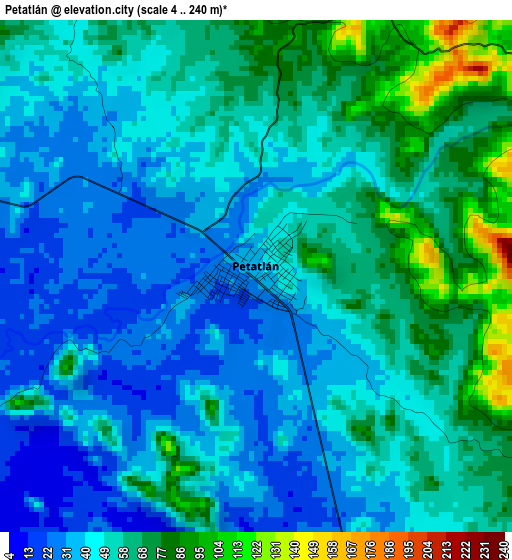
Below is the Elevation map of Petatlán, which displays elevation range with different colors. Scale of the first map is from 4 to 240 m (13 to 787 ft) with average elevation of 52.2 meters (=171 ft) [note 1]
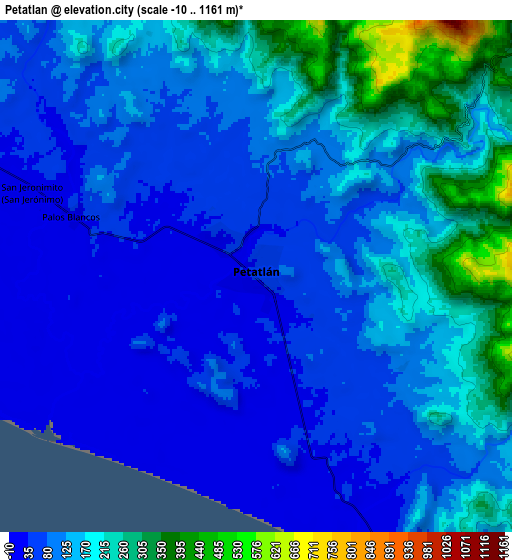
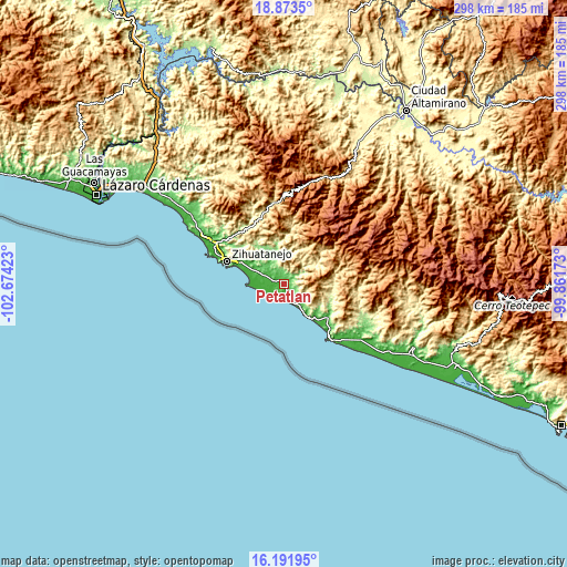
These maps also provides idea of topography and contour of this city, they are displayed at different zoom levels. More info about maps, scale and edge coordinates you can find below images.
| \ | Map #1 | Map #2 | Topo.Map |
| Scale [m] | 4..240 m | -10..1161 m | × |
| Scale [ft] | 13..787 ft | -33..3809 ft | × |
| Average | 52.2 m = 171 ft | 128.6 m = 422 ft | × |
| Width | 9.32 km = 5.8 mi | 18.64 km = 11.6 mi | 298.2 km = 185.3 mi |
| Height | 9.32 km = 5.8 mi | 18.64 km = 11.6 mi | 298.2 km = 185.3 mi |
| ↑Max Latitude | 17.579578° | 17.621466° | 18.8735° |
| Latitude at center | 17.53768° | 17.53768° | 17.53768° |
| ↓Min Latitude | 17.495772° | 17.453855° | 16.19195° |
| ← Min Longitude | -101.311925° | -101.355871° | -102.67423° |
| Longitude center | -101.26798° | -101.26798° | -101.26798° |
| →Max Longitude | -101.224035° | -101.180089° | -99.86173° |
Nearby cities:
Cities around Petatlán sort by population:
• Ixtapa-Zihuatanejo elevation 13 m
32.3 km,  291°
291°
• San José Ixtapa (Barrio Viejo) 14 m
41.5 km,  296°
296°
• El Coacoyul 22 m
24.7 km, 296°
• San Jeronimito 33 m
8.9 km, 292°
• Papanoa 32 m
33.7 km,  134°
134°
• Palos Blancos 32 m
7.2 km, 288°
• Colonia Aeropuerto 23 m
22.2 km, 294°
• Villa Hermosa (Las Pozas) 21 m
23.6 km, 296°
• Coyuquilla Norte 50 m
28.5 km, 127°
• Los Almendros 32 m
19.9 km, 294°
• Los Achotes 35 m
17.3 km, 293°
• San Miguelito 41 m
21 km, 301°
Multilingual:
 En español:
Petatlán elevación 39 m.
 En France:
Petatlán élévation 39 m.


Sources and notes:
- [note 1] Map square and city borders are not equal. Map elevation data is calculated only from area inside that square.
- [src 1] Elevation data from geonames database provided with same terms of usage.
- [src 2] The elevation map of Petatlán is generated using elevation data from NASA's 3 arcsec (90m) resolution SRTM data.
- [src 3] Base (background) map © OpenStreetMap contributors tiles are generated by Geofabrik and OpenTopoMap.
Copyright & License:
This Petatlán Elevation Map is licensed under CC BY-SA. You may reuse any part from this page, if you give a proper credit by linking to this URL:
 More info on terms of use page.