Concepción la Venta elevation
Concepción la Venta (State of Mexico, San José del Rincón), Mexico elevation is 2808 meters and Concepción la Venta elevation in feet is 9213 ft above sea level [src 1]. Concepción la Venta is a populated place (feature code) with elevation that is 1494 meters (4902 ft) bigger than average city elevation in Mexico.
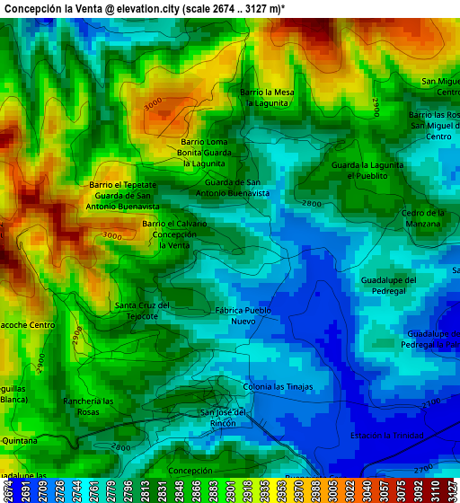
Below is the Elevation map of Concepción la Venta, which displays elevation range with different colors. Scale of the first map is from 2674 to 3127 m (8773 to 10259 ft) with average elevation of 2831.5 meters (=9290 ft) [note 1]
These maps also provides idea of topography and contour of this city, they are displayed at different zoom levels. More info about maps, scale and edge coordinates you can find below images.
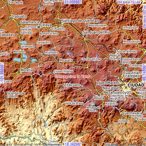
| \ | Map #1 | Topo.Map |
| Scale [m] | 2674..3127 m | × |
| Scale [ft] | 8773..10259 ft | × |
| Average | 2831.5 m = 9290 ft | × |
| Width | 9.2 km = 5.7 mi | 294.4 km = 182.9 mi |
| Height | 9.2 km = 5.7 mi | 294.4 km = 182.9 mi |
| ↑Max Latitude | 19.73281° | 21.00988° |
| Latitude at center | 19.69144° | 19.69144° |
| ↓Min Latitude | 19.650059° | 18.36206° |
| ← Min Longitude | -100.195755° | -101.55806° |
| Longitude center | -100.15181° | -100.15181° |
| →Max Longitude | -100.107865° | -98.74556° |
Nearby cities:
Cities around Concepción la Venta sort by population:
• San Miguel Agua Bendita elevation 2806 m
10.2 km,  131°
131°
• Ejido la Soledad 2758 m
7 km,  137°
137°
• Fábrica Concepción 2708 m
6.6 km,  165°
165°
• Santiago Oxtempan 2931 m
10.4 km,  17°
17°
• San Miguel del Centro 2910 m
5.6 km,  54°
54°
• San José del Rincón Centro 2757 m
3.3 km,  182°
182°
• Cedro de la Manzana 2803 m
3.7 km,  88°
88°
• Concepción del Monte 2847 m
4.5 km, 183°
• Dotegiare 2773 m
11.5 km,  81°
81°
• San Isidro 2669 m
10.1 km,  327°
327°
• Colonia Cuauhtémoc 2930 m
9.7 km,  12°
12°
• Guadalupe Buenavista 2700 m
9.2 km,  163°
163°
Multilingual:
 En español:
Concepción la Venta elevación 2808 m.
 En France:
Concepción la Venta élévation 2808 m.
 Auf Deutsch:
Concepción la Venta höhe über dem Meeresspiegel ist 2808 m.
 На русском:
Concepción la Venta высота над уровнем моря 2808 м
Sources and notes:
- [note 1] Map square and city borders are not equal. Map elevation data is calculated only from area inside that square.
- [src 1] Elevation data from geonames database provided with same terms of usage.
- [src 2] The elevation map of Concepción la Venta is generated using elevation data from NASA's 3 arcsec (90m) resolution SRTM data.
- [src 3] Base (background) map © OpenStreetMap contributors tiles are generated by Geofabrik and OpenTopoMap.
Copyright & License:
This Concepción la Venta Elevation Map is licensed under CC BY-SA. You may reuse any part from this page, if you give a proper credit by linking to this URL:
 More info on terms of use page.