Dotegiare elevation
Dotegiare (State of Mexico, San Felipe del Progreso), Mexico elevation is 2773 meters and Dotegiare elevation in feet is 9098 ft above sea level [src 1]. Dotegiare is a populated place (feature code) with elevation that is 1459 meters (4787 ft) bigger than average city elevation in Mexico.
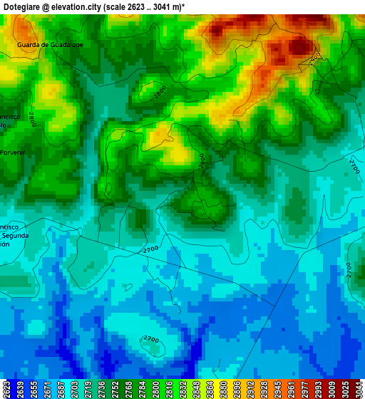
Below is the Elevation map of Dotegiare, which displays elevation range with different colors. Scale of the first map is from 2623 to 3041 m (8606 to 9977 ft) with average elevation of 2746.7 meters (=9011 ft) [note 1]
These maps also provides idea of topography and contour of this city, they are displayed at different zoom levels. More info about maps, scale and edge coordinates you can find below images.
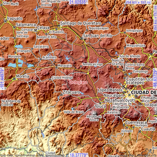
| \ | Map #1 | Topo.Map |
| Scale [m] | 2623..3041 m | × |
| Scale [ft] | 8606..9977 ft | × |
| Average | 2746.7 m = 9011 ft | × |
| Width | 9.2 km = 5.7 mi | 294.4 km = 182.9 mi |
| Height | 9.2 km = 5.7 mi | 294.4 km = 182.9 mi |
| ↑Max Latitude | 19.748416° | 21.02535° |
| Latitude at center | 19.70705° | 19.70705° |
| ↓Min Latitude | 19.665673° | 18.37779° |
| ← Min Longitude | -100.087485° | -101.44979° |
| Longitude center | -100.04354° | -100.04354° |
| →Max Longitude | -99.999595° | -98.63729° |
Nearby cities:
Cities around Dotegiare sort by population:
• San Juan Coajomulco elevation 2651 m
9.4 km,  56°
56°
• Calvario del Carmen 2648 m
8.7 km,  156°
156°
• San Lucas Ocotepec 2722 m
8.1 km,  113°
113°
• Purísima Concepción Mayorazgo 2723 m
4.7 km, 111°
• San Miguel Agua Bendita 2806 m
9.3 km,  203°
203°
• Ejido la Soledad 2758 m
9.5 km,  223°
223°
• Calvario Buenavista 2646 m
9.1 km,  92°
92°
• San Miguel del Centro 2910 m
7 km,  282°
282°
• Cedro de la Manzana 2803 m
7.8 km,  257°
257°
• El Obraje 2611 m
8.6 km,  78°
78°
• El Carmen Ocotepec 2727 m
7.6 km, 106°
• Rincón de los Pirules 2852 m
3.8 km,  21°
21°
Multilingual:
 En español:
Dotegiare elevación 2773 m.
 En France:
Dotegiare élévation 2773 m.
 Auf Deutsch:
Dotegiare höhe über dem Meeresspiegel ist 2773 m.

Sources and notes:
- [note 1] Map square and city borders are not equal. Map elevation data is calculated only from area inside that square.
- [src 1] Elevation data from geonames database provided with same terms of usage.
- [src 2] The elevation map of Dotegiare is generated using elevation data from NASA's 3 arcsec (90m) resolution SRTM data.
- [src 3] Base (background) map © OpenStreetMap contributors tiles are generated by Geofabrik and OpenTopoMap.
Copyright & License:
This Dotegiare Elevation Map is licensed under CC BY-SA. You may reuse any part from this page, if you give a proper credit by linking to this URL:
 More info on terms of use page.