San Isidro elevation
San Isidro (Michoacán, Tlalpujahua), Mexico elevation is 2669 meters and San Isidro elevation in feet is 8757 ft above sea level [src 1]. San Isidro is a populated place (feature code) with elevation that is 1355 meters (4446 ft) bigger than average city elevation in Mexico.
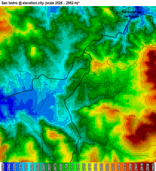
Below is the Elevation map of San Isidro, which displays elevation range with different colors. Scale of the first map is from 2526 to 2952 m (8287 to 9685 ft) with average elevation of 2690.7 meters (=8828 ft) [note 1]
These maps also provides idea of topography and contour of this city, they are displayed at different zoom levels. More info about maps, scale and edge coordinates you can find below images.
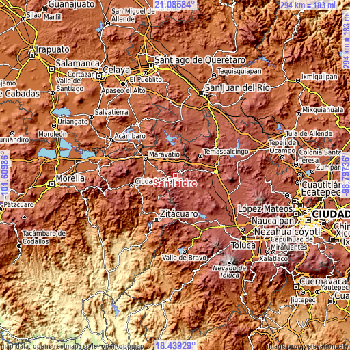
| \ | Map #1 | Topo.Map |
| Scale [m] | 2526..2952 m | × |
| Scale [ft] | 8287..9685 ft | × |
| Average | 2690.7 m = 8828 ft | × |
| Width | 9.2 km = 5.7 mi | 294.3 km = 182.9 mi |
| Height | 9.2 km = 5.7 mi | 294.3 km = 182.9 mi |
| ↑Max Latitude | 19.80941° | 21.08584° |
| Latitude at center | 19.76806° | 19.76806° |
| ↓Min Latitude | 19.726699° | 18.43929° |
| ← Min Longitude | -100.247555° | -101.60986° |
| Longitude center | -100.20361° | -100.20361° |
| →Max Longitude | -100.159665° | -98.79736° |
Nearby cities:
Cities around San Isidro sort by population:
• El Oro de Hidalgo elevation 2748 m
8.5 km,  63°
63°
• Tlalpujahua de Rayón 2583 m
5.2 km,  36°
36°
• Santiago Oxtempan 2931 m
8.7 km,  80°
80°
• San Miguel del Centro 2910 m
11.2 km,  117°
117°
• Santa María de los Ángeles 2708 m
2.1 km,  12°
12°
• Tupátaro 2425 m
11.8 km,  295°
295°
• Venta de Bravo 2296 m
11.1 km,  16°
16°
• Santa Rosa de Lima 2720 m
11.4 km, 80°
• San Nicolás el Oro 2724 m
9.9 km, 64°
• San Pedro Tarímbaro 2599 m
5 km,  332°
332°
• Concepción la Venta 2808 m
10.1 km,  147°
147°
• Colonia Cuauhtémoc 2930 m
7.6 km, 82°
Multilingual:
 En español:
San Isidro elevación 2669 m.
 En France:
San Isidro élévation 2669 m.
 Auf Deutsch:
San Isidro höhe über dem Meeresspiegel ist 2669 m.

Sources and notes:
- [note 1] Map square and city borders are not equal. Map elevation data is calculated only from area inside that square.
- [src 1] Elevation data from geonames database provided with same terms of usage.
- [src 2] The elevation map of San Isidro is generated using elevation data from NASA's 3 arcsec (90m) resolution SRTM data.
- [src 3] Base (background) map © OpenStreetMap contributors tiles are generated by Geofabrik and OpenTopoMap.
Copyright & License:
This San Isidro Elevation Map is licensed under CC BY-SA. You may reuse any part from this page, if you give a proper credit by linking to this URL:
 More info on terms of use page.