Ansihuacuaro elevation
Ansihuacuaro (Michoacán, Penjamillo), Mexico elevation is 1699 meters and Ansihuacuaro elevation in feet is 5574 ft above sea level [src 1]. Ansihuacuaro is a populated place (feature code) with elevation that is 385 meters (1263 ft) bigger than average city elevation in Mexico.
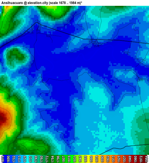
Below is the Elevation map of Ansihuacuaro, which displays elevation range with different colors. Scale of the first map is from 1678 to 1984 m (5505 to 6509 ft) with average elevation of 1723.2 meters (=5654 ft) [note 1]
These maps also provides idea of topography and contour of this city, they are displayed at different zoom levels. More info about maps, scale and edge coordinates you can find below images.
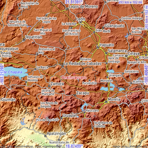
| \ | Map #1 | Topo.Map |
| Scale [m] | 1678..1984 m | × |
| Scale [ft] | 5505..6509 ft | × |
| Average | 1723.2 m = 5654 ft | × |
| Width | 9.17 km = 5.7 mi | 293.5 km = 182.4 mi |
| Height | 9.17 km = 5.7 mi | 293.5 km = 182.4 mi |
| ↑Max Latitude | 20.241077° | 21.51391° |
| Latitude at center | 20.19984° | 20.19984° |
| ↓Min Latitude | 20.158592° | 18.87459° |
| ← Min Longitude | -101.850645° | -103.21295° |
| Longitude center | -101.8067° | -101.8067° |
| →Max Longitude | -101.762755° | -100.40045° |
Nearby cities:
Cities around Ansihuacuaro sort by population:
• Angamacutiro de la Unión elevation 1705 m
11.4 km,  119°
119°
• Numarán 1686 m
16.2 km,  292°
292°
• Villachuato 1695 m
18.8 km,  107°
107°
• Penjamillo de Degollado 1704 m
17.1 km,  231°
231°
• El Maluco 1698 m
15 km, 114°
• Ziquítaro 1826 m
17.6 km,  209°
209°
• Potreros 1703 m
16.7 km,  68°
68°
• San Miguel Epejan 1797 m
14.9 km,  183°
183°
• Santa Fe del Río 1691 m
2.2 km,  281°
281°
• Mezquite de Luna 1682 m
14.1 km,  320°
320°
• Guándaro 1695 m
7.1 km,  262°
262°
• Agua Caliente 1731 m
16.8 km,  153°
153°
Multilingual:
 En español:
Ansihuacuaro, Anciguacaro elevación 1699 m.
 En France:
Ansihuacuaro élévation 1699 m.
 Auf Deutsch:
Ansihuacuaro höhe über dem Meeresspiegel ist 1699 m.

Sources and notes:
- [note 1] Map square and city borders are not equal. Map elevation data is calculated only from area inside that square.
- [src 1] Elevation data from geonames database provided with same terms of usage.
- [src 2] The elevation map of Ansihuacuaro is generated using elevation data from NASA's 3 arcsec (90m) resolution SRTM data.
- [src 3] Base (background) map © OpenStreetMap contributors tiles are generated by Geofabrik and OpenTopoMap.
Copyright & License:
This Ansihuacuaro Elevation Map is licensed under CC BY-SA. You may reuse any part from this page, if you give a proper credit by linking to this URL:
 More info on terms of use page.