Numarán elevation
Numarán (Michoacán), Mexico elevation is 1686 meters and Numarán elevation in feet is 5531 ft above sea level [src 1]. Numarán is a seat of a second-order administrative division (feature code) with elevation that is 372 meters (1220 ft) bigger than average city elevation in Mexico.
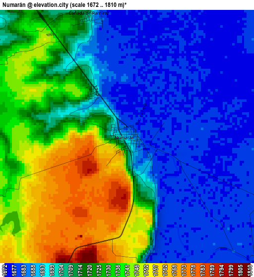
Below is the Elevation map of Numarán, which displays elevation range with different colors. Scale of the first map is from 1672 to 1810 m (5486 to 5938 ft) with average elevation of 1711.5 meters (=5615 ft) [note 1]
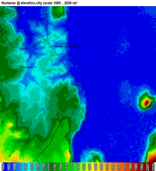
These maps also provides idea of topography and contour of this city, they are displayed at different zoom levels. More info about maps, scale and edge coordinates you can find below images.
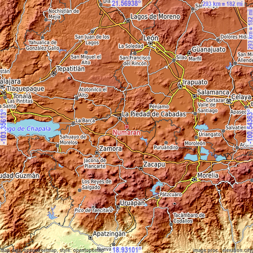
| \ | Map #1 | Map #2 | Topo.Map |
| Scale [m] | 1672..1810 m | 1669..2020 m | × |
| Scale [ft] | 5486..5938 ft | 5476..6627 ft | × |
| Average | 1711.5 m = 5615 ft | 1720.8 m = 5646 ft | × |
| Width | 9.17 km = 5.7 mi | 18.34 km = 11.4 mi | 293.4 km = 182.3 mi |
| Height | 9.17 km = 5.7 mi | 18.34 km = 11.4 mi | 293.4 km = 182.3 mi |
| ↑Max Latitude | 20.297022° | 20.338233° | 21.56938° |
| Latitude at center | 20.2558° | 20.2558° | 20.2558° |
| ↓Min Latitude | 20.214567° | 20.173323° | 18.93101° |
| ← Min Longitude | -101.993825° | -102.037771° | -103.35613° |
| Longitude center | -101.94988° | -101.94988° | -101.94988° |
| →Max Longitude | -101.905935° | -101.861989° | -100.54363° |
Nearby cities:
Cities around Numarán sort by population:
• La Piedad elevation 1698 m
12.8 km,  318°
318°
• Santa Ana Pacueco 1686 m
12.3 km,  325°
325°
• Laguna Larga de Cortés 1683 m
15.3 km,  3°
3°
• Las Cañadas 1719 m
5.5 km, 327°
• Río Grande 1678 m
11.4 km, 329°
• Zináparo 1846 m
10.5 km,  208°
208°
• Santa Fe del Río 1691 m
14.1 km,  114°
114°
• Cañada de Ramírez 1703 m
4.7 km,  342°
342°
• Mezquite de Luna 1682 m
7.6 km,  52°
52°
• Guándaro 1695 m
10.6 km,  131°
131°
• Estación la Piedad 1681 m
13.4 km, 337°
• Colonia Morelos 1679 m
13.6 km,  22°
22°
Multilingual:
 En español:
Numarán elevación 1686 m.
 En France:
Numarán élévation 1686 m.
 Auf Deutsch:
Numarán höhe über dem Meeresspiegel ist 1686 m.

Sources and notes:
- [note 1] Map square and city borders are not equal. Map elevation data is calculated only from area inside that square.
- [src 1] Elevation data from geonames database provided with same terms of usage.
- [src 2] The elevation map of Numarán is generated using elevation data from NASA's 3 arcsec (90m) resolution SRTM data.
- [src 3] Base (background) map © OpenStreetMap contributors tiles are generated by Geofabrik and OpenTopoMap.
Copyright & License:
This Numarán Elevation Map is licensed under CC BY-SA. You may reuse any part from this page, if you give a proper credit by linking to this URL:
 More info on terms of use page.