Arandas elevation
Arandas (Guanajuato, Irapuato), Mexico elevation is 1736 meters and Arandas elevation in feet is 5696 ft above sea level [src 1]. Arandas is a populated place (feature code) with elevation that is 422 meters (1385 ft) bigger than average city elevation in Mexico.
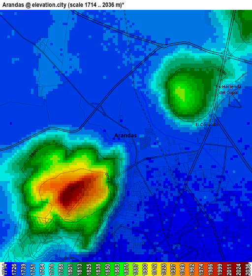
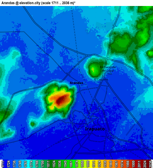
Below is the Elevation map of Arandas, which displays elevation range with different colors. Scale of the first map is from 1714 to 2036 m (5623 to 6680 ft) with average elevation of 1762.1 meters (=5781 ft) [note 1]
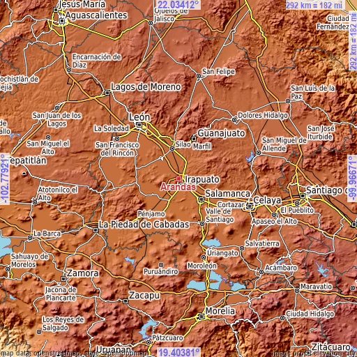
These maps also provides idea of topography and contour of this city, they are displayed at different zoom levels. More info about maps, scale and edge coordinates you can find below images.
| \ | Map #1 | Map #2 | Topo.Map |
| Scale [m] | 1714..2036 m | 1711..2036 m | × |
| Scale [ft] | 5623..6680 ft | 5614..6680 ft | × |
| Average | 1762.1 m = 5781 ft | 1750.4 m = 5743 ft | × |
| Width | 9.14 km = 5.7 mi | 18.28 km = 11.4 mi | 292.5 km = 181.8 mi |
| Height | 9.14 km = 5.7 mi | 18.28 km = 11.4 mi | 292.5 km = 181.8 mi |
| ↑Max Latitude | 20.765776° | 20.806861° | 22.03412° |
| Latitude at center | 20.72468° | 20.72468° | 20.72468° |
| ↓Min Latitude | 20.683573° | 20.642454° | 19.40381° |
| ← Min Longitude | -101.416905° | -101.460851° | -102.77921° |
| Longitude center | -101.37296° | -101.37296° | -101.37296° |
| →Max Longitude | -101.329015° | -101.285069° | -99.96671° |
Nearby cities:
Cities around Arandas sort by population:
• Irapuato elevation 1720 m
5.6 km,  161°
161°
• Villas de Irapuato 1781 m
5.4 km,  218°
218°
• Lo de Juárez 1768 m
5.9 km,  34°
34°
• Carrizal Grande 1744 m
7.3 km,  106°
106°
• El Carrizalito 1728 m
5.6 km, 114°
• Hacienda de Márquez 1748 m
6.3 km,  12°
12°
• El Copalillo 1745 m
2.9 km,  83°
83°
• La Caja 1762 m
6.9 km,  257°
257°
• Ex-Hacienda del Copal 1756 m
4.3 km,  65°
65°
• Serrano 1743 m
6.4 km,  338°
338°
• Taretán 1766 m
7.2 km, 33°
• Guadalupe de Paso Blanco 1739 m
4.6 km,  316°
316°
Multilingual:
 En español:
Arandas elevación 1736 m.
 En France:
Arandas élévation 1736 m.
 Auf Deutsch:
Arandas höhe über dem Meeresspiegel ist 1736 m.

Sources and notes:
- [note 1] Map square and city borders are not equal. Map elevation data is calculated only from area inside that square.
- [src 1] Elevation data from geonames database provided with same terms of usage.
- [src 2] The elevation map of Arandas is generated using elevation data from NASA's 3 arcsec (90m) resolution SRTM data.
- [src 3] Base (background) map © OpenStreetMap contributors tiles are generated by Geofabrik and OpenTopoMap.
Copyright & License:
This Arandas Elevation Map is licensed under CC BY-SA. You may reuse any part from this page, if you give a proper credit by linking to this URL:
 More info on terms of use page.