Irapuato elevation
Irapuato (Guanajuato), Mexico elevation is 1720 meters and Irapuato elevation in feet is 5643 ft above sea level [src 1]. Irapuato is a seat of a second-order administrative division (feature code) with elevation that is 406 meters (1332 ft) bigger than average city elevation in Mexico.
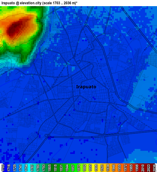
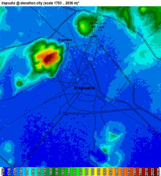
Below is the Elevation map of Irapuato, which displays elevation range with different colors. Scale of the first map is from 1703 to 2036 m (5587 to 6680 ft) with average elevation of 1738.4 meters (=5703 ft) [note 1]
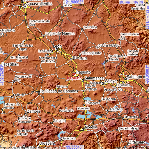
These maps also provides idea of topography and contour of this city, they are displayed at different zoom levels. More info about maps, scale and edge coordinates you can find below images.
| \ | Map #1 | Map #2 | Topo.Map |
| Scale [m] | 1703..2036 m | 1703..2036 m | × |
| Scale [ft] | 5587..6680 ft | 5587..6680 ft | × |
| Average | 1738.4 m = 5703 ft | 1738.8 m = 5705 ft | × |
| Width | 9.14 km = 5.7 mi | 18.29 km = 11.4 mi | 292.6 km = 181.8 mi |
| Height | 9.14 km = 5.7 mi | 18.29 km = 11.4 mi | 292.6 km = 181.8 mi |
| ↑Max Latitude | 20.717859° | 20.758957° | 21.98662° |
| Latitude at center | 20.67675° | 20.67675° | 20.67675° |
| ↓Min Latitude | 20.63563° | 20.594498° | 19.35548° |
| ← Min Longitude | -101.400225° | -101.444171° | -102.76253° |
| Longitude center | -101.35628° | -101.35628° | -101.35628° |
| →Max Longitude | -101.312335° | -101.268389° | -99.95003° |
Nearby cities:
Cities around Irapuato sort by population:
• Arandas elevation 1736 m
5.6 km,  341°
341°
• Villas de Irapuato 1781 m
5.2 km,  282°
282°
• Carrizal Grande 1744 m
6.2 km,  57°
57°
• El Carrizalito 1728 m
4.5 km,  47°
47°
• El Copalillo 1745 m
5.7 km,  11°
11°
• El Carmen 1717 m
4.4 km,  202°
202°
• Fraccionamiento las Liebres 1718 m
5.2 km,  231°
231°
• San Javier 1730 m
7.7 km,  262°
262°
• Peñuelas 1744 m
7.6 km, 53°
• Ex-Hacienda del Copal 1756 m
7.5 km,  17°
17°
• Las Huertas Tercera Sección 1719 m
4.7 km,  235°
235°
• San José de Bernalejo (El Guayabo) 1718 m
6.2 km, 228°
Multilingual:
 En español:
Irapuato elevación 1720 m.
 En France:
Irapuato élévation 1720 m.
 Auf Deutsch:
Irapuato höhe über dem Meeresspiegel ist 1720 m.

Sources and notes:
- [note 1] Map square and city borders are not equal. Map elevation data is calculated only from area inside that square.
- [src 1] Elevation data from geonames database provided with same terms of usage.
- [src 2] The elevation map of Irapuato is generated using elevation data from NASA's 3 arcsec (90m) resolution SRTM data.
- [src 3] Base (background) map © OpenStreetMap contributors tiles are generated by Geofabrik and OpenTopoMap.
Copyright & License:
This Irapuato Elevation Map is licensed under CC BY-SA. You may reuse any part from this page, if you give a proper credit by linking to this URL:
 More info on terms of use page.