Arteaga elevation
Arteaga (Coahuila), Mexico elevation is 1679 meters and Arteaga elevation in feet is 5509 ft above sea level [src 1]. Arteaga is a seat of a second-order administrative division (feature code) with elevation that is 365 meters (1198 ft) bigger than average city elevation in Mexico.
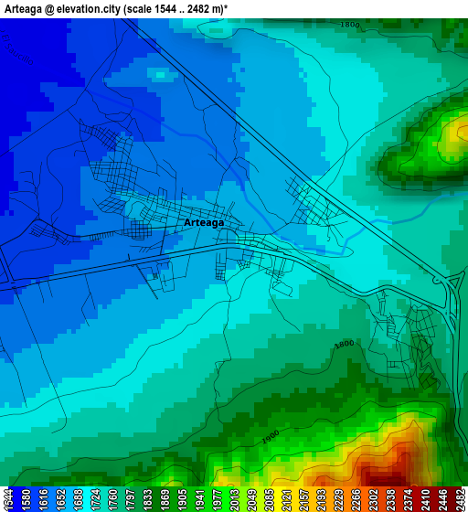
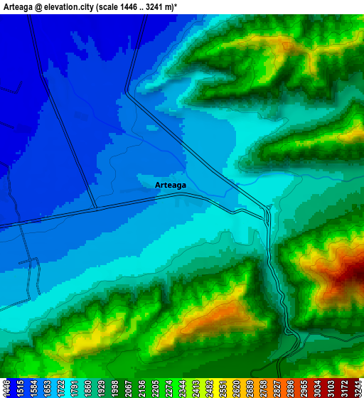
Below is the Elevation map of Arteaga, which displays elevation range with different colors. Scale of the first map is from 1544 to 2482 m (5066 to 8143 ft) with average elevation of 1734.2 meters (=5690 ft) [note 1]
These maps also provides idea of topography and contour of this city, they are displayed at different zoom levels. More info about maps, scale and edge coordinates you can find below images.
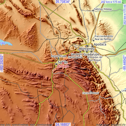
| \ | Map #1 | Map #2 | Topo.Map |
| Scale [m] | 1544..2482 m | 1446..3241 m | × |
| Scale [ft] | 5066..8143 ft | 4744..10633 ft | × |
| Average | 1734.2 m = 5690 ft | 1897.1 m = 6224 ft | × |
| Width | 8.82 km = 5.5 mi | 17.65 km = 11 mi | 282.4 km = 175.5 mi |
| Height | 8.82 km = 5.5 mi | 17.65 km = 11 mi | 282.4 km = 175.5 mi |
| ↑Max Latitude | 25.484956° | 25.524619° | 26.70834° |
| Latitude at center | 25.44528° | 25.44528° | 25.44528° |
| ↓Min Latitude | 25.405591° | 25.365889° | 24.16883° |
| ← Min Longitude | -100.890615° | -100.934561° | -102.25292° |
| Longitude center | -100.84667° | -100.84667° | -100.84667° |
| →Max Longitude | -100.802725° | -100.758779° | -99.44042° |
Nearby cities:
Cities around Arteaga sort by population:
• Saltillo elevation 1592 m
16.1 km,  261°
261°
• Santa Catarina 675 m
46.5 km,  56°
56°
• San Pedro Garza García 656 m
50.2 km, 61°
• San Pedro Garza Garcia 663 m
50.4 km, 62°
• García 719 m
47.8 km,  31°
31°
• Ramos Arizpe 1413 m
14.5 km,  315°
315°
• Valle de Lincoln 617 m
53.5 km,  43°
43°
• San Antonio de las Alazanas 2190 m
33.2 km,  125°
125°
• Huachichil 2097 m
26.1 km,  175°
175°
• Agua Nueva 1935 m
37.4 km,  220°
220°
• San Juan de la Vaquería 1820 m
43.2 km,  240°
240°
• Las Torres de Guadalupe 739 m
46 km, 29°
Multilingual:
 En español:
Arteaga elevación 1679 m.
 En France:
Arteaga élévation 1679 m.
 Auf Deutsch:
Arteaga höhe über dem Meeresspiegel ist 1679 m.

Sources and notes:
- [note 1] Map square and city borders are not equal. Map elevation data is calculated only from area inside that square.
- [src 1] Elevation data from geonames database provided with same terms of usage.
- [src 2] The elevation map of Arteaga is generated using elevation data from NASA's 3 arcsec (90m) resolution SRTM data.
- [src 3] Base (background) map © OpenStreetMap contributors tiles are generated by Geofabrik and OpenTopoMap.
Copyright & License:
This Arteaga Elevation Map is licensed under CC BY-SA. You may reuse any part from this page, if you give a proper credit by linking to this URL:
 More info on terms of use page.