García elevation
García (Nuevo León), Mexico elevation is 719 meters and García elevation in feet is 2359 ft above sea level [src 1]. García is a seat of a second-order administrative division (feature code) with elevation that is 595 meters (1952 ft) smaller than average city elevation in Mexico.
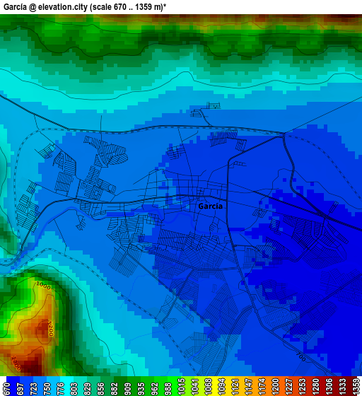
Below is the Elevation map of García, which displays elevation range with different colors. Scale of the first map is from 670 to 1359 m (2198 to 4459 ft) with average elevation of 785.7 meters (=2578 ft) [note 1]
These maps also provides idea of topography and contour of this city, they are displayed at different zoom levels. More info about maps, scale and edge coordinates you can find below images.
| \ | Map #1 | Map #2 | Topo.Map |
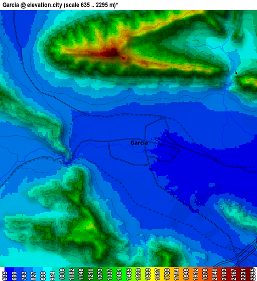
| Scale [m] | 670..1359 m | 635..2295 m | × |
| Scale [ft] | 2198..4459 ft | 2083..7530 ft | × |
| Average | 785.7 m = 2578 ft | 923.4 m = 3030 ft | × |
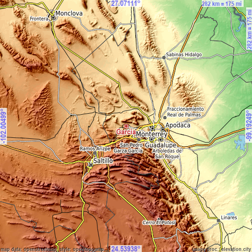
| Width | 8.8 km = 5.5 mi | 17.6 km = 10.9 mi | 281.5 km = 174.9 mi |
| Height | 8.8 km = 5.5 mi | 17.59 km = 10.9 mi | 281.5 km = 174.9 mi |
| ↑Max Latitude | 25.851564° | 25.891105° | 27.07111° |
| Latitude at center | 25.81201° | 25.81201° | 25.81201° |
| ↓Min Latitude | 25.772443° | 25.732862° | 24.53938° |
| ← Min Longitude | -100.642685° | -100.686631° | -102.00499° |
| Longitude center | -100.59874° | -100.59874° | -100.59874° |
| →Max Longitude | -100.554795° | -100.510849° | -99.19249° |
Nearby cities:
Cities around García sort by population:
• Santa Catarina elevation 675 m
20.9 km,  137°
137°
• Parque Industrial Ciudad Mitras 593 m
15.3 km,  99°
99°
• Mitras Poniente 592 m
17.8 km, 103°
• Valle de Lincoln 617 m
12.3 km, 99°
• Mina 591 m
22.1 km,  18°
18°
• Alianza Real 545 m
22.1 km,  78°
78°
• Los Parques 619 m
13.1 km, 100°
• Monclova Primer Sector 557 m
19.6 km,  89°
89°
• Praderas de San Francisco 555 m
19.7 km, 87°
• Monclova Segundo Sector 554 m
20.2 km, 88°
• Unión Agropecuarios Lázaro Cárdenas del Norte 541 m
21.6 km, 84°
• Las Torres de Guadalupe 739 m
2.5 km,  254°
254°
Multilingual:
 En español:
García elevación 719 m.
 En France:
García élévation 719 m.


Sources and notes:
- [note 1] Map square and city borders are not equal. Map elevation data is calculated only from area inside that square.
- [src 1] Elevation data from geonames database provided with same terms of usage.
- [src 2] The elevation map of García is generated using elevation data from NASA's 3 arcsec (90m) resolution SRTM data.
- [src 3] Base (background) map © OpenStreetMap contributors tiles are generated by Geofabrik and OpenTopoMap.
Copyright & License:
This García Elevation Map is licensed under CC BY-SA. You may reuse any part from this page, if you give a proper credit by linking to this URL:
 More info on terms of use page.